nanling national forest park
Nanling National Forest Park is the largest nature reserve in Guangdong Province and a treasure house of rare animals and plants. The park is located in the core of Nanling Mountains, at the junction of Ruyuan Yao Autonomous County and Hunan Province. It is 70 kilometers southeast of Shaoguan City, 50 kilometers north of Pingshi Town and 10 kilometers east of Beijing-Zhuhai Expressway Bridge, covering an area of 273 square kilometers.
There are more than 2,000 species of plants and the only virgin forest in Guangdong. Established in 1993 with the approval of the Ministry of Forestry, it is the center of subtropical broad-leaved green forest in China, where a large area of virgin forest preserves the most complete natural ecosystem. In 2012, Nanling National Forest Park became a national 4A-level tourist attraction.
Location context
Nanling National Forest Park is located in the northern part of Guangdong Province, at the junction of Ruyuan County, Yangshan County, Lechang County and Yizhang County, Hunan Province. It is located in the south-central zone of Nanling Mountain. It is adjacent to Mangshan National Forest Park in Hunan Province in the north, Dadongshan Nature Reserve in the west, Tianjingshan Forest Farm and Nanshuihu Reservoir in the south, and Bibei Yaozhai Village in the east. The total area of the park is 273 square kilometers.
Nanling Mountains is the largest mountain range and an important physical and geographical boundary in southern China. Located in the border of Hunan Province, Jiangxi Province, Guangdong Province and Guangxi Zhuang Autonomous Region. It is located in the core area of the Wuling Mountains, in the south-central area of the Dayuling Mountains, Qitianling Mountains, Dupangling Mountains, Mengzhuling Mountains and Yuechengling Mountains. Around 24 00 ~26 30 north latitude lies between Hunan and Guangxi, Hunan and Guangdong, Jiangxi and Guangdong, extending eastward to southern Fujian. The East and West are about 600 kilometers long and the South and North are about 200 kilometers wide. Because Nanling is composed of five main mountains, Yuechengling, Dupang, Mengzhu, Qitianling and Dayuling, it is also called Wuling. They are generally distributed in the East-West direction. It is the watershed between the Yangtze River and the Pearl River. In a broad sense, Nanling also includes Miaoer Mountain, Ocean Mountain, Jiuyi Mountain, Xianghualing Mountain, Yaoshan Mountain and Jiulianshan Mountain.
geographical environment
topographic features
Nanling National Forest Park is the highest mountain area in Guangdong. Shikengkong is the "first peak in Guangdong" at 1902 meters above sea level, and Shitaoling is the second peak in Guangdong at 1888 meters above sea level. The surrounding peaks are high and scattered. Here is the largest primeval forest in Guangdong Province, which is the "rich land of biodiversity in Lingnan". The trees in the mountains are linked together and beyond sight. Old trees grow very tall. There are pine and cypress trees in the forest, as well as various animals; Arrowhead bamboo in Nanling Mountains, all kinds of strange flowers and plants, all over the park. From the foot of the mountain, evergreen broad-leaved forest, coniferous broad-leaved mixed forest and alpine low forest form three vertical landscape belts.
climatic conditions
The vertical distribution of climate in Nanling is very obvious, which is suitable for summer summer. The climate is a typical subtropical warm and humid climate. The difficult terrain is relatively high, and it has the characteristics of mountain climate. The annual average temperature is 17.7 C. The highest temperature is 34.4 C. The lowest temperature is - 3.6 C. The frost period in winter is longer, and the longest year can reach 100 days. When the strong cold air in the north goes south, there is ice in the mountain areas. In some years, there is drifting snow or snow. Precipitation is abundant, averaging 1705 mm, the highest year can reach 2495 mm; March into the rainy season, rainfall concentrated in March - August. The annual average relative humidity is 84, the annual average foggy day is 70 days, the hydrothermal condition is superior, suitable for all kinds of plant growth. The climate is mild and pleasant. Because of the rainy mountainous areas, the development of surface runoff, the large flow of streams, and the large ratio of river bed, there are dangerous beaches and waterfalls, which are rich in hydraulic resources.
Main
attractions
Xiaohuangshan Scenic Area
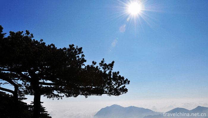
Xiaohuangshan is 1600 meters above sea level, the peak is Rufeng, where the world's largest "Guangdong pine" virgin forest is preserved. In winter, we can see the unique ice hanging and fog landscape of the South. The most peculiar thing about Guangdong pine is that the color of its leaves varies with the seasons. It is green and yellow in spring and summer and pink and blue in winter, so it is called Blue Pine. At the viewing platform at the entrance of Xiaohuangshan Mountain, there is a famous "Welcoming Pine". Throughout the year, it stands on the peak wall and stretches its hospitable arms to welcome guests.
Main attractions: Guangdong welcoming pine, Lianli pine forest, cloud, peak Buddha light, Rufeng.
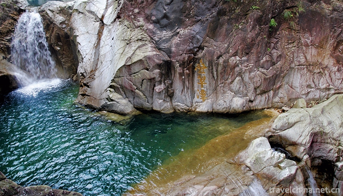
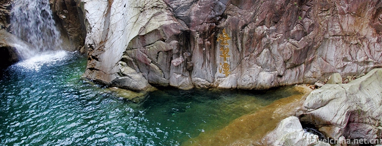
Waterfalls Scenic Spot
Waterfalls are the largest natural waterfalls in South China. The number, scale and elevation of waterfalls are very large. The waterfall originated in the second peak of Facailing Mountain (1888 meters above sea level) in Guangdong Province, and fell down in the deep valley with a drop of nearly 500 meters, forming nearly 100 large and small waterfalls, the most famous of which is the eight waterfalls mentioned above. Along the way, the green trees and flowers blossom, and there are short-tailed monkeys, squirrels and all kinds of flying birds and fishes survive, forming a scene.
There are eight big waterfalls from top to bottom: kilometer waterfall, peacock waterfall, flying waterfall, heart-stirring waterfall, Hukou waterfall, Qingxin waterfall, phonological waterfall and Shuangfei waterfall.
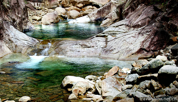
Hydrophilic Valley Scenic Area
Water Valley is famous for its "Youxia, Bitan and Qishi". The cliffs in the scenic area stand up, and you can feel the quiet in the valley. Birds often fly around in the mountains. Especially in spring and summer, wild flowers are blooming all over the valley, butterflies are dancing, which is known as "Valley of Lovers". The typical pot cave landforms are preserved here, which has become a great wonder of Nanling.
Note: Pot cave landform is a kind of circular cave formed by abrasion of river bed with sand and gravel in the jet stream. Because of the eddy current, gravel will dig and drill the river bed. Under the abrasion of water flow, deep pits are often formed under the river interruption layer, different lithology or falling water. The wall of the pot cave is smooth as a mirror, and its shape is like a well. Geomorphologically, it is called "pot cave". Main attractions: Feihua Lake, Pearl Lake, Jiuqu Lake, Qingsong Lake, Tongyou Gorge, fairy pool and Wolong Gorge.
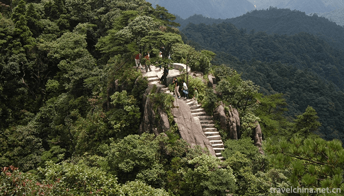
Shikeng Kongkong Scenic Area
Shikengkong, with an elevation of 1902 meters, is known as the "Guangdong Roof". The mountain peaks soar into the clouds and the scenery is changeable. The old site of the Air Force Radar Station can arouse people's reverie about history. The scenery at the top of the mountain varies from four o'clock to four o'clock. Rhododendron is bright red in spring, dotted with mountains; sunrise and sunset in summer and autumn; ice-bound thousands of miles in winter, silver-coated, a "northern scenery".
Main points of view: Jinchan Wangyue, the old site of Air Force Radar Station, Cloud Sea, Sunrise.
Traffic routes
Self driving
Route from Guangzhou to Nanling:
1. Starting from Guangzhou - South China Express Line on Huangpu Avenue - heading north - through Taihe Toll Station to get on the highway.
2. Passage: Conghua City - Fogang - Yingde - Shaoguan - Shaoguan Ruyuan County - Ruyuan Station - Dongping Station - Daqiao Station (Sign: Nanling Park of Bridge).
3. After paying the toll at the "Bridge" Expressway Toll Station, turn right 50 meters ahead. Go 1.8 kilometers further to the T-junction and turn right (you can see the sign on it: Nanling National Forest Park or Wuzhishan). The Orange House Hotel is visible from 8 kilometers to Wuzhishan living area. The road and bridge fee is 145 yuan. There is a gas station one kilometer from the park gate.
Nanling to Guangzhou route:
From the highway on the bridge to the South - via Shaoguan - Yingde - Fogang - Conghua - Aotou Station, turn right at the highway (without turning) to 105 National Highway - turn right at T-junction to Guangzhou direction - return to Zhongluotan to Beijing-Zhuhai Expressway southbound to Guangzhou.
Public transportation
From Guangzhou to Shaoguan by train or bus, you can go to Shaoguan Xihe Bus Station by bus (taxi from Shaoguan Railway Station to Xihe Bus Station is 4 yuan without jumping meter).
Take the Zhongba Bus on Nanling National Forest Park Special Line
Shaoguan Railway Station (Square) Morning: (7:45) to Nanling National Forest Park
Shaoguan Railway Station (Square) at noon: (11:15) to Nanling National Forest Park
Shaoguan Railway Station (Square) Lower and Upper: (3:15) Open - Nanling National Forest Park
Shaoguan Xihe Bus Station in the morning: (8:00) To Nanling National Forest Park
Shaoguan Xihe Bus Station at noon: (11:45) Open - Nanling National Forest Park
Shaoguan Xihe Bus Station opens at 3:30 p.m. - Nanling National Forest Park
Ruyuan County Bus Station in the morning: (9:00) To Nanling National Forest Park
Ruyuan County Bus Station at noon: (12:45) to Nanling National Forest Park
Ruyuan County Bus Station afternoon: (4:30) to Nanling National Forest Park
Nanling National Forest Park in the morning: (7:30) to Shaoguan Railway Station (via Ruyuan County Town)
Nanling National Forest Park at noon: (12:30) to Shaoguan Railway Station (via Ruyuan County Town)
Nanling National Forest Park in the afternoon: (3:30) to Shaoguan Railway Station (via Ruyuan County Town)
Note: Shaoguan Bus Station can be taken to Ruyuan County by car, about an hour's drive. Subsequently, we rented minivans in Ruyuan (about 50-80 yuan) or chose to take the bus to Daqiao Town to Nanling National Forest Park intersection.
Route guide
1. Guangzhou-Beijing-Zhuhai Expressway (towards Beijing and Shaoguan) - through Ruyuan County Town and Nanshuihu Lake - through the exit of "Bridge, Nanling National Forest Park", turn right at the Expressway - go straight to the road sign "towards Wuzhishan" - and arrive at the gate of the park. The whole journey is 285 kilometers, about 3 hours'drive. The cost of road and bridge is about 125 yuan. There is a gas station one kilometer away from the park gate.
2. Wuguang Express Line:
A. Guangzhou Nanyu - Shaoguan Station - Shaoguan Xihe Bus Station - Ruyuan Bus Station - Nanling National Forest Park. The whole journey is about 2.5 hours and the fare is about 150 yuan.
B. Guangzhou North (Huadu) - Shaoguan Station - Shaoguan Xihe Bus Station - Ruyuan Bus Station - Nanling National Forest Park. The whole journey is about 2.2 hours and the fare is about 120 yuan.
Historical humanism
Nanling Mountain is the largest Yao nationality inhabited area in China, so the Yao nationality has a nickname of "Alpine Nationality" in China. However, this nickname not only belongs to Yao nationality, but also to some Han nationality. Hakka, a branch of the Han nationality, is called "alpine nationality" among the Han people. Many people only know that the mountainous area at the border of Fujian, Guangdong and Jiangxi Province is a Hakka community, but they do not know that it is only in terms of population density, if the scope is said, Nanling area should be the largest Hakka community. Hakkas should start from the old settlements of Fujian, Guangdong and Jiangxi, migrate westward along the Nanling Mountains, and then spread to southwest China, Southeast Asia and overseas along both wings. Why did the Hakkas migrate along the axis of Nanling?
First, the original place of residence is too small and mountainous area, which can not support so many people, so we must expand the space outward.
Second, Nanling is a subtropical region with flourishing growth of animals and plants, which can provide abundant food sources.
3. Nanling is a mountainous area. The working and living styles of Yao nationality and Hakka people in mountainous areas are adapted to the natural conditions of North and south.
In the mountainous areas of the South and north, Yao people live in the mountains, while guests live in the foothills. They are also "mountainous nationalities" living happily with Junanling. The similarity also lies in people's language and habits. Nanling is the junction of four provinces. It is reasonable that the language will be very complex, but they speak Hakka dialect more uniformly. When they communicate with each other, whether adults or children, they will also speak a "mandarin" - a language with distinct northern dialect characteristics.
nanling national forest park
-
The Mutianyu Great Wall
The Mutianyu Great Wall in Beijing is located in Huairou District of Beijing, 73 kilometers from the urban area of Beijing. With a long history and splendid culture
Views: 144 Time 2018-11-24 -

Fuping Pottery Art Village
Pottery Village is located in the north of Fuping County. It relies on the site of Tang Dingzhou Kiln. It is a cultural and custom experience scenic spot consisting of a quasi-three-star hotel, three
Views: 171 Time 2019-01-12 -
Ginseng Chicken Hotpot
Wash ginseng, boil it in a little water, take out slices, and cook it in the original pot for 15 minutes. Still soak it in the original soup. All the above ingredients except hen nuggets and ginseng s
Views: 261 Time 2019-03-24 -
Jianchuan Opera
Jianchuan Baiqu is an ancient music variety with a long history and wide spread in Bai nationality area. It is mainly popular in Jianchuan, Eryuan and Tongdian, Jinding and Jiuhe of Lanping County, Nu
Views: 326 Time 2019-05-05 -
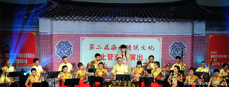
Quanzhou North Pipe
Beiguan, also known as Beiqu, Xiaoqu, Quzi, is a kind of traditional folk silk and bamboo music widely spread in Quangang District, Quanzhou City, Fujian Province. China's Beiguan is now only distribu
Views: 235 Time 2019-06-11 -
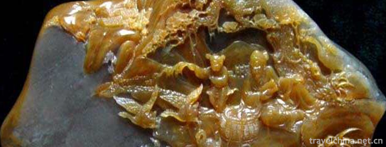
Shoushan stone carving
Shoushan Stone Carving is a traditional folk carving art. It is made of Shoushan Stone, which is produced in the northern mountain area of Fuzhou. It is a small carving for people to enjoy through spe
Views: 144 Time 2019-06-15 -
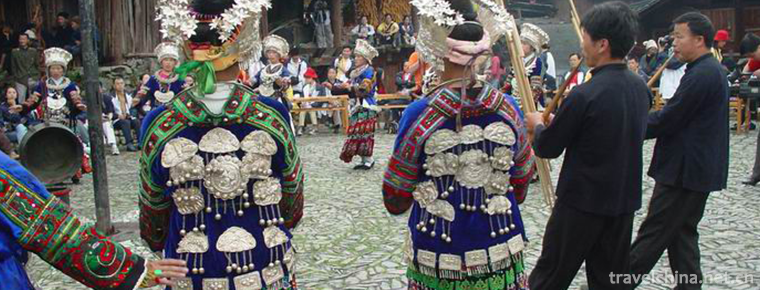
Bronze drum dance
Tonggu dance is one of the most popular and influential ancient dances among the Zhuang and Yi people in Wenshan Zhuang and Miao Autonomous Prefecture of Yunnan Province. It is distributed in Zhuang a
Views: 109 Time 2019-06-21 -

Machirev
Machirev is a name for a form of dance and entertainment, which refers to a large-scale self-entertainment activity with a large number of participants (the so-called participation refers to those who
Views: 122 Time 2019-07-06 -

Legend of Yin Jifu
The "Yin Jifu Legend" which was listed as the first batch of intangible cultural heritage in Hubei Province, made a sensation forum about "Chinese poetry ancestor, Taishi Yin Jifu of th
Views: 198 Time 2019-07-13 -

Southwest Jiaotong University
Southwest Jiaotong University is a national key university directly under the Ministry of Education. The first batch of national "double first-class", "211 project", "characte
Views: 187 Time 2019-08-31 -

Nanchong landform
Nanchong terrain inclines from north to south, with an altitude of 256-888.8 meters. The main geomorphic types are hills, and 1 / 3 of them are high hills and low mountains, middle hills and valleys, and low hills and dams. The geomorphic types of the whole city
Views: 344 Time 2020-12-17 -
Nanchong City honor
"Three products" strategy demonstration city of consumer goods industry, charming city with Chinese characteristics, national garden city and excellent tourism city in China
Views: 309 Time 2020-12-17