Enshi Grand Canyon
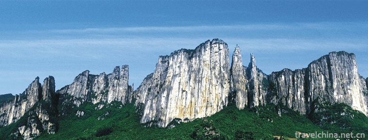
Enshi Grand Canyon is located in Tunpu Township and Banqiao Township, Enshi City, Hubei Province. It is located at the junction of Hunan, Chongqing and Hubei provinces. It is the most beautiful section of the Qingjiang River Basin.
Enshi Grand Canyon has opened two core scenic spots, Qixingzhai and Yunlong Ground Fissure, with a total area of 35.2 square kilometers. Tiankeng, Ground Fissure, Cliff, Peak Cluster, Rock Pillar Group, Karst Cave, Underground River and other geological landscapes are all available.
Enshi Grand Canyon Scenic Area is a national AAAAA-class tourist attraction, with many world-class tourist resources.
In December 2015, Enshi Grand Canyon was selected as one of the 30 best new tourist landscapes in the Three Gorges of the Yangtze River.
Main attractions
A fragrant incense
Bingxiang is a rare Triassic limestone column on the earth. Its height is 150 meters, its bottom diameter is 6 meters, and its minimum diameter is only 4 meters. Its rock compressive strength is 800 kilograms per cubic centimeter. The wind blows him down, the rain hits him, and it stands proudly among the peaks for tens of millions of years. It is rare to guard this mysterious land.
He looked like a man's root, showing his majesty, like a treasure of the town Valley in the Grand Canyon.
Legend has it that this stone pillar is an unpleasant fragrance given to the local people by the God of heaven. If it is ignited by disasters, the God will come down to save suffering when he sees a few green smoke. Therefore, the local people call it "unpleasant fragrance", which is long and thin. When the sky is clear, a white cloud overlaps on the top of the peak and looks like the incense in the sky from a distance. Like a fairyland; in rainy weather, a mist rises, like a wisp of green yarn, dressing it up like a faint, charming and moving.
Geologically speaking, because of the long-term staggered influence of the Yangtze and Qingjiang rivers, continuous erosion and erosion, the steep pillars are formed today. Because of the extremely difficult preservation, the similar slender pillars on the earth are rare, and the longest and largest one is this.
Cliff of Qixing Village
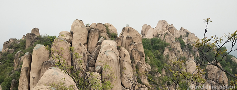
Qixingzhai cliff is a giant columnar rock mass group developed in Triassic limestone. It stands upright on steep slopes, towering forests and spectacular. It is different from the peak forest and stone forest, but a pillar mountain, so it is called "rock pillar forest".
The right "rock pillar" is actually a huge rock pillar, 800 meters long, 150 meters wide and nearly 200 meters high. The top of the pillar is an arc plane with two high ends and low middle. This is because there is a small catchment pool in the middle of the top, forming a surface depression.
During the reign of the Republic of China in the 1940s, more than a dozen young men hid on the top of it for more than ten days. At the top of the peak, they could still find the cooking utensils they lived in.
Twin Tower
The Triassic limestone is formed by weathering, denudation and dissolution as a symmetrical two-column mountain body, which is not connected with each other and stares at each other.
This is because the rocks themselves are of the same nature and the structural fissures are regular, which are formed under the direct erosion of heavy rain along the vertical fissures. But the two mountains are symmetrical and almost identical in shape, which is rare in nature.
Peak cluster of small building
The Grand Canyon area is located in the Bamianshan Platform fold belt in the upper Yangtze platform (Grade I), Lichuan Platform fold belt in Grade I I (Grade I I I), and Enshitai fold belt in the south-east.
The study area is located in the core of Mufu anticline in Yupize anticline. The northwest side is the front Hill syncline and the southeast side is Tuanbao syncline. The direction of the main tectonic line is 40 to 60 to the east of the north.
Mufu anticline is an asymmetrical broad and gentle anticline, with a dip angle of 10 15 in the axis and a slight steepness of 30 to 50 in the wing.
Regional geological structural factors make two sets of well-developed vertical joints in the strata. Nearly north-south and east-west joints in the strata cross each other in a grid form.
The open core area of anticline makes the strata of Triassic Jialingjiang Formation gentle, which is conducive to the formation and preservation of rock pillars.
Recurrent crustal movements have inherited and reformed the tectonic fissure system in the core of the anticline. The fissures have been deepened and lengthened, and the openness has gradually increased, which provides favorable spatial conditions for surface water infiltration, groundwater migration and storage, and is conducive to surface and underground erosion and erosion.
Along these vertical joints, the surface and groundwater cut the rock wall, which gradually enlarges the vertical joints and forms broad karst troughs on the rock wall, some of which pass directly from the top to the bottom of the rock wall.
With the gradual uplift of the crust and the intensification of downcutting, the rock pillars are gradually separated from the rock wall, and finally a rock pillar group is formed near the rock wall.
The Triassic limestone is weathered, dissolved and collapsed to form the peak forest landform of depression. It is composed of several single rock pillars and isolated peaks, with different heights and scattered patterns. It is magnificent, magnificent and beautiful.
Cliffs cluster
The karst spectacle coexisting with cliff and peak clusters is very rare in the karst developed areas of Southwest China, which is related to the western part of Hubei Province where the Grand Canyon lies in the slope zone of the second to third steps in the giant geomorphic units of China, and also to the huge drop caused by the uplift of mountainous areas in Western Hubei Province and the subsidence of Jianghan Basin.
The geotectonic unit in the Grand Canyon area belongs to the Bamianshan fold belt from Yangtze Jianghuai Platform to the secondary tectonic unit. The north part of the belt is the central Hubei fold zone, which is adjacent to the Sichuan platform depression in the West and extends to the basin in the east. The main direction of tectonic line in this area is NE or NE, in which faults are well developed and folds are relatively weak.
The main bottom strata in the region are Sinian (Z) - Triassic (T) strata, which reflect the palaeogeographic environment of the shelf surface sea, including the shore of Kuang Guang or carbonate platform and shallow sea shelf sea.
Extensive carbonate deposits laid the foundation for later karstification and karst landscape formation.
The Grand Canyon is located in the northeastern end of the Yunnan-Guizhou Plateau.
In addition, it is located in the subtropical monsoon area, which forms the general characteristics of hydrology and climate in this area, such as plum rain, early summer rainstorm and autumn rain. However, due to the surroundings of mountains in most parts of the country, the clouds and peaks overlap, and the changeable topography, it also forms its unique local climate. There are many microclimates of cloud, rain and fog, due to the great difference in surface elevation. It reflects the vertical difference of climate and forms a special three-dimensional climatic zone in mountainous areas. At the same altitude, various climatic types are formed because of the different combination of slope direction, slope position, slope shape and its small terrain structure.
Enshi Grand Canyon is a temperate monsoon climate. It has no extreme heat in summer, less severe cold in winter, abundant sunshine and distinct seasons. The average temperature for many years is 15-17 C. The highest temperature is in August, which is 27-30 C. The lowest temperature is in December and January, which is 2-8 C.
The annual average relative humidity is 70%~80%, which is higher in winter than in summer. The annual average evaporation is 720 mm, the largest in July and August, accounting for about 33%. The frost period averaged about 4 months.
Building peak cluster
The overall morphology is similar to that of Wulingyuan quartz sandstone peak forest in Zhangjiajie, but its rock composition is limestone. Looking at it, dozens of limestone peaks and pillars are rugged, compact and widely distributed, forming a vast pillar-type peak forest. The limestone strata of the Triassic Jialingjiang Formation vary in thickness from tens of centimeters to 1 meter. The occurrence of the strata is very gentle. Nearly horizontal, the strata are like thousands of layered pillars stacked by blocks of rock. Because the stone is hard, the pillar is vertical and upright, the strata are thick and the occurrence (inclination and dip angle) is gentle. It is not easy to slide along the strata between each strata. It can support pillars up to 100 meters without toppling or falling at the top. In the rock stratum, two groups of joints, nearly north-south and east-west, crisscross each other in grid form, cut the stone pillars into quadrangles, and split the rock along the two groups of intersecting vertical joint planes.
Stone scroll
Before the invention of paper, the bamboo slips used by the Han people to record history, while the Tujia people carved the characters on the flat stones to form stone slips. The stacked thin beds of rock in front of them may be the Historical Library of the Ba people. In fact, it was a masterpiece of the sea 200 million years ago, when a vast ocean was deposited with calcium in the water. Marine fossils could be found in it. Geologically, it is now called the thin-bedded limestone of the Middle Triassic Jialingjiang Formation. This "stone scroll" is actually a true record of the evolution of the earth's history.
Travel Tips
Tickets for scenic spots: 200 yuan per person
Opening hours: 8:30-15:00
Suggested Play Time: 2 Days
Best tourist season: April-November is suitable.
Introduction
Enshi Grand Canyon is located in Tunpu Township and Banqiao Township, Enshi City. It is a section of the Qingjiang Grand Canyon. It is 108 kilometers long and has a great development value of 300 square kilometers. In addition to the large river canyon, the biggest feature of the landscape is the typical and rich karst landforms on both sides: sinkholes, fissures, natural bridges, karst caves (more than 200), overlapping peaks, and cliffs almost perpendicular to the canyon.


-
Alice tomato noodles
The Ali brand was born in 2001 and officially launched in 2005. The brand popularity and honor of Ali Juice Noodle series products are constantly improving.
Views: 239 Time 2018-11-26 -
Chengji Mountain Tourist Scenic Spot
Qiu Mountain, also known as Linglong Mountain, Xianshan Mountain on a journey to the West and Qiu Mountain Scenic Area, is located in Suiping County, Zhumadian City, Henan Province.
Views: 128 Time 2018-12-09 -
Chaoyang Bird Fossil National Geological Park
Chaoyang Bird Fossil World Geopark is located in Chaoyang City, western Liaoning Province. Chaoyang is located at the junction of Liaoning, Hebei and Mongolia provinces in the throat of Chinese cock t.
Views: 105 Time 2019-01-05 -
Huhu Water Eco Scenic Spot
Located in the southwestern edge of Pingshan County, Hebei Province, the old revolutionary area, the Biaoshui Eco-Scenic Spot has a tourist area of 11.5 square kilometers, an altitude of 800-1100 mete.
Views: 218 Time 2019-01-12 -
Shanghai Changfeng Ocean World
Shanghai Changfeng Ocean World belongs to the world's largest aquarium chain brand of Merlin Entertainment Group, which is the first and second largest in Europe.
Views: 222 Time 2019-03-17 -
Canadian Tibetan carpet weaving skills
Canadian Tibetan carpet weaving skills, traditional handicraft in Huangzhong County, Qinghai Province, one of the national intangible cultural heritage..
Views: 103 Time 2019-05-05 -
The Art of the Peking Solo stringed Orchestra
The unique charm of the unique stringed instrument art of the Jing ethnic minority in China. It is a non-material cultural heritage project of the Beijing solo string art in Guangxi Zhuang Autonomous .
Views: 362 Time 2019-05-07 -
Kirgiz hawk taming custom
Originating in the East, the Falcon has a history of 4000 years. The custom of taming Eagles has been handed down orally without any written records. However, the Kirgiz people have kept the saying .
Views: 132 Time 2019-05-09 -
Quyi
Quyi is the general name of all kinds of "rap art" of the Chinese nation. It is a unique art form formed by the long-term development of folk oral literature and singing art. According to in.
Views: 158 Time 2019-06-11 -
Chengdu Jinsha Site Museum
Chengdu Jinsha Site Museum, a national AAAA tourist attraction, is located at No.2 Jinsha Ruins Road, Qingyang District, Chengdu City, Sichuan Province. It covers an area of 456 Mu and a building area of 38000 square meters..
Views: 211 Time 2020-11-06 -
Suining climate
Suining City is located in the Asian monsoon area, belonging to the subtropical humid monsoon climate in Sichuan Basin. It has a mild climate, abundant rainfall, four distinct seasons and a significant monsoon climate. The frost free period is long in winter and spring..
Views: 355 Time 2020-12-16 -
Neijiang population
By the end of 2019, the total population of Neijiang's household registration was 4 million 81 thousand and 800, a decrease of 35 thousand and 900 from the end of last year, of which 2 million 103 thousand and 400 were male and 19 thousand were reduced.
Views: 346 Time 2020-12-16

