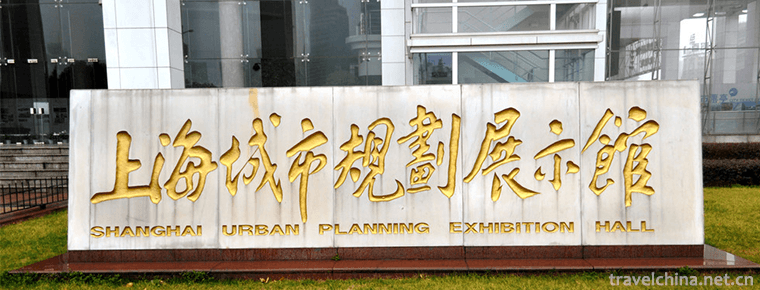
Shanghai Urban Planning Exhibition Hall
The Shanghai Urban Planning Exhibition Hall was completed in early 2000 and opened to the public on February 25, 2000. As an important window for Shanghai's external publicity, Shanghai Urban Planning Exhibition Hall, under the leadership of Shanghai Municipal Committee and Municipal Government, demonstrates the achievements of Shanghai's urban planning and construction development to the people of Shanghai and even the world. It enables the citizens to know about urban planning, participate in urban planning and builds a communication bridge between the municipal government and the citizens. After seven years of efforts, the Shanghai Urban Planning Exhibition Hall has become a civilized unit in Shanghai, a national AAAA tourist attraction, a national (and Shanghai) popular science education base, a patriotic education base in Shanghai, a environmental protection education base in Shanghai, and a vocational training base. It has passed the certification of ISO 9001:2000 quality management system.
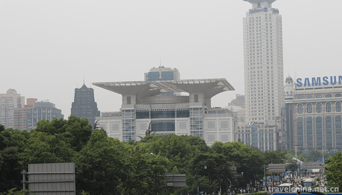
introduce
The Shanghai Urban Planning Exhibition Hall is a professional venue with abundant information, complete facilities and comprehensive display of Shanghai's image by combining tradition with modernity, highlighting the use of high technology and embodying the characteristics of comprehensive, open and public participation. The theme of the exhibition is "city, people, environment and development". It was officially opened in February 2000. After five years of exhibition, it has received more than 2 million audiences. In 2004, according to the future development of Shanghai, it was readjusted and updated. The content, information, knowledge, interesting and interactive participation were greatly enhanced. It vividly and vividly demonstrated that the Shanghai Urban Planning Exhibition Hall, located on the east side of the People's Square Municipal Government Building and the north side of the People's Park, was in 2020. It is an important window to show the achievements of Shanghai's urban planning and construction. It integrates exhibition, tourism, reception, business and leisure. Planning Museum is not only one of the landmark buildings in Shanghai, but also the latest highlight of urban tourism in People's Square area.
The building area of the pavilion is more than 20,000 square meters. In the exhibition area of more than 7000 square meters, Shanghai's achievements in urban planning and construction are fully displayed, which fully expresses the theme of "city, people, environment and development", and is praised as the "window of the city" by the citizens. Museum uses a large number of high-tech means to fully display the future blueprint of Shanghai to 2020. The whole planning hall is very professional, knowledgeable, interesting and artistic. It integrates history and future and gives people unlimited reverie. The magnificent momentum, the magnificent style of layout and display, the modern first-class high-tech display means, vividly deduce the vicissitudes of Shencheng, showing Shanghai's beautiful today and brilliant tomorrow.
With the theme of "city, people, environment and development", the Shanghai Urban Planning Exhibition Hall fully demonstrates the "yesterday, today and tomorrow" of Shanghai's urban development by means of detailed and authoritative information, pictures, models, touch screens and multimedia demonstrations. It is the best choice for us to fully understand and understand Shanghai.
In the exhibition hall, there are city models made according to the actual area of Shanghai reduced 500 times, nostalgic old streets of Shanghai in 1930s, and future urban landscape of Shanghai presented by high-tech means such as virtual reality and phantom imaging. Its main features are:
1. Virtual reality: the first domestic high-tech virtual film and television for tourists to watch.
2. Phantom imaging: The 14-meter-long phantom imaging system, Nanjing Road, reflects the historical and cultural landscape of the First Commercial Street of China. It is the longest phantom imaging system in China.
3. Information Port: Shanghai Information Port shows the recent development of information technology in e-commerce, industrial design, urban management, distance education, medical revolution and intelligent families. Through high-tech technologies such as virtual reality, digital movies and surface acoustic touch, we can show you the infinite charm of the future network society.
4. Big urban planning model: The urban planning model of more than 600 square meters vividly shows all the buildings with more than 6 stories in the inner ring line. This model is the world's largest urban planning model. It shows you the blueprint of urban planning before 2020, which is the highest in Guinness.
Overall distribution
The exhibition hall covers an area of more than 3600 square meters, with a total floor area of 18390 square meters. The main structure is 43.3 meters high, including five floors above ground and two floors below ground. The library is divided into three functional areas. It takes two hours for the visitors to walk from bottom to top in the pavilion and browse through it in a hurry.
partition
Lobby
The artistic model of "Shanghai Morning" in the first floor lobby, which integrates the landmark buildings of different periods in Shanghai freely, has a magnificent momentum and opened the prelude of tourists'visit. The giant relief of "Million Citizens Relocation" and the largest high-definition large-screen demonstration wall of indoor LED in China can set off the atmosphere with bright colors and high-definition pictures, and can be demonstrated according to needs.
Interlayer
Historic and Cultural City Hall reflects the vicissitudes of Shanghai's vicissitudes over the past century, and shows the rich historical and cultural connotations of Shanghai's urban development. With the help of simulation scenes, film and television performances, phantom imaging and other multimedia demonstration means, the interaction and participation of the exhibition will be enhanced and the unique urban cultural connotation of old Shanghai will be presented. The use of phantom imaging and other composite technologies to show the beautiful scenery of "100 years of prosperity" of Yu Garden shows the unique cultural scene in the south of the Yangtze River. Exhibits such as old Shanghai photographs, historical materials of "Great Shanghai Plan" and past Shanghai planning maps adopt the form of self-help drawing to increase the audience's sense of participation. Twelve historic nature reserves in Shanghai are introduced in detail in the form of pictures. The photo album of "Changing Shanghai" provided by Xu's father and son during the past 30 years at the same place and at different times reflects in detail the great changes of Shanghai in the past and the present.
Second Floor - Exhibition Hall
In order to reflect the latest developments of Shanghai's urban planning and the overall cultural and artistic accomplishments of Shanghai citizens, since 2001, the Planning Museum has opened temporary exhibition venues on the second floor, supplemented by exhibition halls on the first and fifth floors, which are suitable for various needs. Almost 70 exhibitions have been held from more than a dozen countries around the world, of which some people are more concerned about. Exhibitions of project planning, cultural exchanges between Shanghai and friendly cities of other countries, as well as many exhibitions of cultural relics and fine works of art have exerted an important influence throughout the city. In 2002, China's bid for the 2010 World Expo was hosted by the International Exhibition Bureau delegation headed by Ms. Carmen Saiwen, Vice-Chairman of the Bureau of International Exhibitions and Chairman of the Executive Committee. China's successful bid for the 2010 Shanghai World Expo has played an important role.
Three Levels - General Planning Hall
Focusing on the present and future of Shanghai's urban development, this paper focuses on the model of the main body of the city in the core area of Shanghai, and uses the integrated technology of sound, light and electricity to reflect the urban landscape of Shanghai from 2020. The model covers an area of more than 600 square meters, supplemented by socio-economic and district planning and construction exhibition areas, and pilot urban planning exhibition areas during the Tenth Five-Year Plan period. Help you understand the future development of Shanghai.
The overall planning exhibition area is equipped with a large-scale broadscreen film and television viewing platform, which comprehensively introduces the "1999-2020 Shanghai Urban Master Plan", giving people a visual impact and shock.
Pudong New Area exhibition area also installed the first domestic stereo film and television system without glasses. Through four-dimensional animation, this paper introduces the historical process of the rise of Lujiazui in Pudong in the 1990s.
The first 360 degree multi-functional virtual studio in China adopts advanced demonstration technology, and will invite you to participate in the "Magic Journey of Shanghai". Through nearly 8 minutes of 360 degree three-dimensional animation demonstration, you can experience the speed and fashion of this beautiful city in Shanghai in an all-round way.
During the Tenth Five-Year Plan period, the pilot town planning exhibition area mainly introduces the planning of "two cities and eight towns".
The Window of the World exhibition area provides a stage for displaying the international metropolitan style and friendly city exchanges to enhance friendship between countries, cities and cities. It is also an important position for publicizing the 2010 Shanghai World Expo.
Four Floors - Second Hall of Master Planning
The second Hall of the master plan highlights the various professional plans for Shanghai's future development, including the medium-term and short-term construction plan, the Deepwater port, the airport and information port, the Huangpu River development and the comprehensive harnessing of the Suzhou River; the comprehensive urban transportation, municipal infrastructure planning, environmental protection, greening, real estate, tourism and other exhibition areas, where all kinds of hi-tech display means are used to enable tourists to All-round inquiry about the bright future of Shanghai.
The "Three Ports" exhibition area emphasizes the creation of atmosphere, the "Information Port" exhibition area emphasizes the integration and application of multimedia system and the construction of tourist inquiry system, while the "Airport" exhibition area skillfully utilizes the airport's scenery, site characteristics, props and objects, bringing visitors a strong sense of visual impact and extension; and the Deepwater Port exhibition area is in the blue sky background of the blue sea. Under the "virtual sailing port area" project, vivid, very manipulative.
The two networks and municipal exhibition area embody the principle of practicability through the most intuitive and vivid display mode and rich and detailed display content, and provide comprehensive traffic planning and municipal planning information of Shanghai and Yangtze River Delta region, which are of the greatest concern to the general public. According to the natural trend of the river and its planning plan, Huangpu River and Suzhou River Exhibition Zone adopt novel large-scale three-dimensional virtual map, cooperate with detailed planning model and multi-media query composite display technology, emphatically embody and introduce the latest planning information.
Greening and environmental protection exhibition area reflects the theme of "harmonious coexistence between man and nature" in a fashionable and freehand way, and strives to build a fully functional inquiry platform for tourists to get information conveniently and accurately.
The residential planning exhibition area constructs a model of the historical evolution of Shanghai's residential buildings, which gives visitors endless imagination and shows the vicissitudes of Shanghai's human settlements environment.
The urban tourism exhibition area adopts the technology of synthetic scenery, which enables visitors to travel and take photos of Shanghai without leaving the museum. Meanwhile, the illusion demonstration further shows the charm of Shanghai.
Five floors - Leisure corridor
On the fifth floor, there are circular exhibition hall, leisure and sightseeing corridor and multi-functional conference hall, overlooking the high ground and giving you a panoramic view of the square.
B1 -- "Shanghai 1930" Style Street
Based on the unique architectural style of Shanghai in the 1930s, the typical modern French, British, Japanese and Spanish architecture and typical Shikumen Lane in Shanghai are displayed to the audience. Every single building facade displayed here can find its prototype and origin in Shanghai. Coming here is like staying in the old Shanghai in the 1930s, where leisure and sightseeing are not interesting.
geographical position
No. 100 Renmin Avenue, Huangpu District, Shanghai (near Tibet Middle Road)
Practical information
Admission ticket
Adults 30 yuan; minors over 6 to 18 years of age, full-time university students and below, and elderly people over 60 years of age with valid certificates 15 yuan; children under 6 years of age or under 1.3 meters of age need to produce valid certificates and accompanied by adults can be exempted from tickets.
Opening Hours
9:00-17:00 (16:00 stop selling tickets); closed on Monday (except for national festivals).
Traffic information
metro
Take Metro Line 1, Line 2, Line 8 to the People's Square, and get out of Gate 2.
transit
Take bus 451, 167, 537, 802, tunnel 6 to Fuzhou Road Station of People's Square, or take 108, 167, 312, 318, 454, 518, 537, 930, 980, Tunnel 3 to Guangdong Road Station of People's Square.
Take the first and second routes of urban tourism to get off at the gate of the city planning exhibition hall.

Shanghai Urban Planning Exhibition Hall
-

Shika Snow Mountain
Sheka snow mountain scenic area is located in the southwest of Jian Tang town in Shangri-La County
Views: 204 Time 2018-10-19 -

Detian waterfall
Detian Waterfall is located in Detian Village, Shuolong Town, Daxin County, Chongzuo City, Guangxi Zhuang Autonomous Region. It is located in the upper reaches of Guichun River on the border between C
Views: 179 Time 2018-12-12 -
Three Gorges Household Scenic Area
Three Gorges Household Scenic Area, National AAAAA Class Tourist Area, the First Batch of Civilized Scenic Area in Hubei Province, Top Ten Scenic Spots in Hubei Province
Views: 164 Time 2018-12-12 -
Qinghai Provincial Museum
Qinghai Museum is located in the east of Xining Square in the west of Xining City. It is the first large-scale comprehensive museum with modern functions in Qinghai
Views: 238 Time 2019-02-07 -
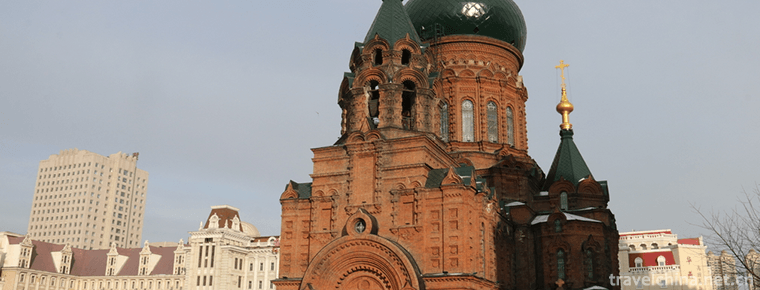
Saint Sophia Cathedral in Harbin
St. Sophia Church is located in Sophia Square, Daoli District, Harbin City, Heilongjiang Province, China. It is a Byzantine-style Orthodox Church built in 1907
Views: 203 Time 2019-02-08 -
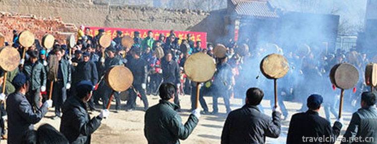
Badang dance
Badang Dance is a kind of ancient folk dance, which originated from the ancient Qiang people's "Temple Festival" in Dingxi Minxian, southeastern Gansu Province. It is also a sacrificial ritu
Views: 210 Time 2019-04-02 -
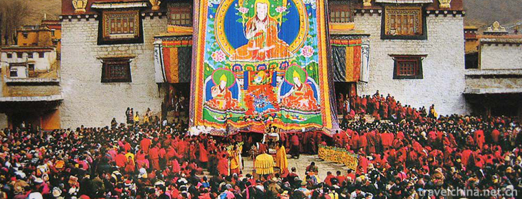
Tibetan New Year
Tibetan calendar year is the traditional festival of the Tibetan people. Bhutan and Mongolia, which are deeply influenced by Tibetan culture, also celebrate the Tibetan New Year
Views: 214 Time 2019-04-04 -
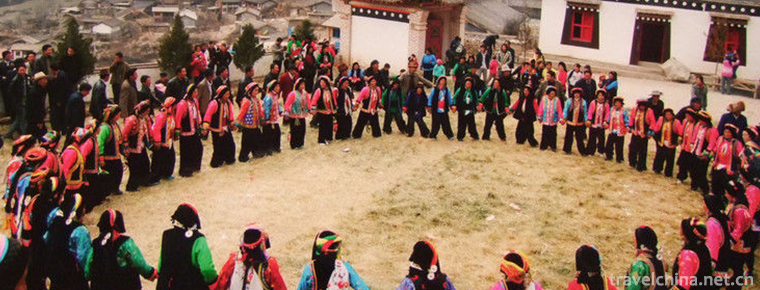
Duodi dances
Multi-place dance, Tibetan folk dance, is a unique way for Tibetan people to dance and sing. It mainly distributes in three areas of Zhouqu County, Gansu Province
Views: 369 Time 2019-04-28 -
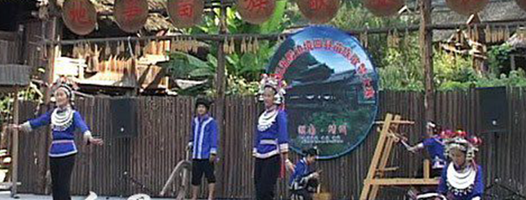
Jingzhou Miao Geku
The Miao people's song (tgong) has been declared as the first batch of national folk intangible cultural heritage and one of the two "national treasures" of Huaihua City.
Views: 155 Time 2019-05-08 -
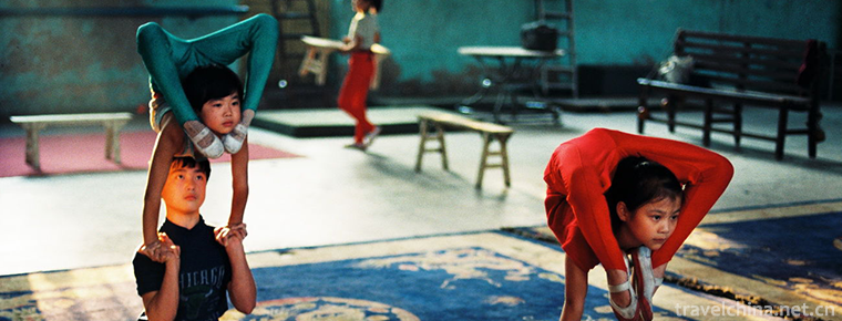
Liaocheng acrobatics
Liaocheng acrobatics is a traditional folk acrobatics art in Shandong Province. Liaocheng is one of the birthplaces of Chinese acrobatics. In the late Neolithic period, Liaocheng was the main area whe
Views: 181 Time 2019-05-13 -
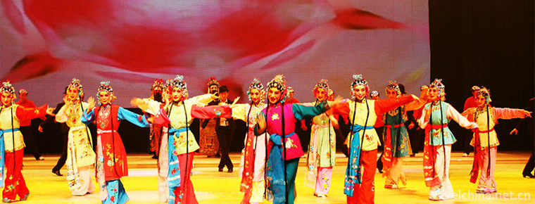
Western Fujian drama
Western Fujian Han Opera, formerly known as "Waijiang Opera", also known as "Ran Tan", is one of the local operas in Fujian. He was born out of foreign operas, absorbed Hakka diale
Views: 224 Time 2019-06-05 -
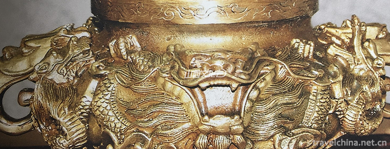
Bronze Ware Making Skills Datong Copper Ware Making Skills
Datong bronze ware is a traditional handicraft of the Han nationality. It has a long history and exquisite craftsmanship. As early as the Northern Wei Dynasty, it enjoyed a great reputation. Since the
Views: 169 Time 2019-06-21