Limutai Natural Scenic Area
Limutai Natural Scenic Area
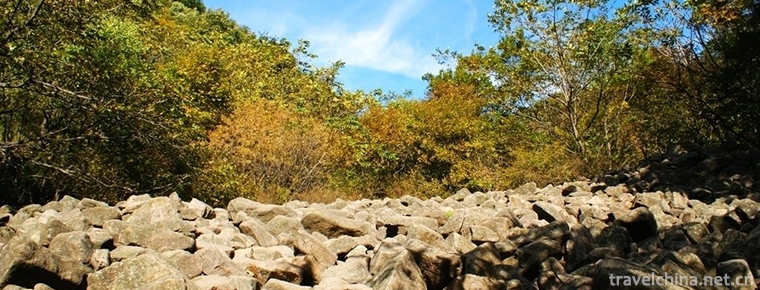
Limutai Natural Scenic Spot is located at the northernmost end of Tianjin, known as "Tianjin Arctic". In the scenic area, the peak forest and canyon are strong and dangerous, the forest landscape is beautiful and quiet, the water of pools and waterfalls is long, and the climbing and winding of vines forms a peculiar natural scenery, which is praised as "Shennongjia of Tianjin" by experts and scholars. Geological landscape here is peculiar, is the typical quartz rock peak forest Canyon landform of Jixian National Geopark, which naturally forms rock painting ridge, Tianjiao, Wuzhishan, ten thousand volumes of Tianshu and other geological landscapes.
geographical environment
Jixian Limutai Natural Scenic Area is one of the three major scenic spots of Tianjin Jiulongshan National Forest Park. It is located in the north of Chuangcangyu Village, Xiaying Town, Jixian County. It is 35 kilometers away from the county town. The total area of the scenic area is 7000 mu. It has a large area of wild azaleas. It is reported that azaleas are distributed 5 kilometers from Huanglaipeng Waterfall to Beidaliang. The most concentrated areas are the Rhododendron Slope, Shihai and Beidaliang, with a total area of nearly 1,000 mu. It is understood that the Rhododendron here belongs to the Rhododendron family Yinghong, deciduous shrubs, early spring flowering, all over the mountains are red, so it is known as "Yingshan Red". With the gradual warming of the temperature, the red Rhododendron blooms in Limutai scenic spot after a year's sleep.
It is understood that the azaleas in Limutai will continue to open for about a month, and the best time to watch the azaleas is in mid-April.
The scenic area integrates food, housing, travel, shopping and entertainment. The catering service department has elegant environment and charming scenery. Here you can enjoy delicious mountain food and eat special dishes.
In order to satisfy the service of eating, living, traveling, traveling, purchasing and entertaining for tourists, the scenic spot has a catering service department with elegant environment, fresh air and charming scenery, and delicious dishes with outstanding characteristics. Visitors can take pictures or rest here. With the background of green hills and beautiful waters, with your beautiful image as the theme, please take the camera in your hand and record this rare moment.
When tourists are intoxicated with the green mountains, natural scenery and geological wonders, they want to know the scenic spot for a night and enjoy the pleasure of life in the mountains. Tourists can live in the farmyard in the scenic area, facing mountains and rivers, green trees and flowers, smelling the scent of mountains and fields, eating delicious meals with strong aroma of the farmhouse, singing several beautiful songs and dancing gracefully with the music. Its music is endless and it is more like a god. Without thinking of a poem: "Qingshan beautiful water to explore the pure land, Qingfeng bright moon back to nature".
There are some special farmyards around the scenic spot, such as Yanlu Health Park, which can provide perfect catering, accommodation, entertainment, conference and other related services for tourists.
Main attractions
Natural landscape
Sandstone peak forest landform - one by one steep and steep peaks, mountains closely linked to form a peak forest, spectacular and beautiful.
Dengtian Joint - Because the dikes running through the mountain are weathered and denuded, the mountain seems to be split in half, with two upright walls, like a line. Being in it is like climbing a gap in the sky.
Wuzhishan - Looking out from here, the edge of the mountain is straight, the slope line is steep and cliff-like, standing five peaks, tall and spectacular, resembling the Buddha's "five fingers stretching the sky".
Fold structure - strata are subjected to horizontal compressive stress, and bending is called folding. The direction of regional or local stress can usually be analyzed according to the fold structure.
Huanglaobao Waterfall - When mountain rivers run through local cliff-like riverbeds, the phenomenon of river water dumping is called a waterfall. Huang Lapeng Waterfall, river bed steep ridge nearly 20 meters high, the river flowing down, very spectacular.
Collapse - Vertical joints of quartz sandstone are well developed and orthogonal to strata. Because the bottom of rock mass is washed away by water all the year round, rock blocks continue to collapse and slide, forming a vertical cliff.
Thousand-layer wave murals - cliffs composed of quartz sandstone, with well-developed rock bedding. Because of erosion, erosion and weathering by current for many years, the rock surface is uneven, like the wind blowing over the water surface, rolling up thousands of waves.
Camel hump - quartz sandstone is intersected by dikes, which are weathered and denuded to form cliff. Looking from a distance, the ridge resembles a camel, and its head, two peaks and tail are clearly visible. This is formed by erosion, weathering and denudation of sandstone.
Group monkeys greet the sun - this is a gentle quartz sandstone due to the development of vertical joints, after weathering and denudation left hieroglyphic stone, like a group of monkeys eastward.
Tibetan Classic Pavilion, a stone tablet, inscribes that 1.8 billion years of huge thick quartz sandstone formed a single-sided mountain. Because of the development of joints, stacked rock blocks are like books in Tibetan Classic Pavilion, countless.
Entertainment items
There are primitive forest sightseeing, Rhododendron Yinghong ornamental tour, ecological popular science tour, rock climbing fitness tour, geological investigation tour, deep mountain treasure hunting tour, leisure vacation tour, pastoral picking tour, old revolutionary area tour, climbing the ancient Great Wall to see the extraterrestrial wonders of green mountains and waters sightseeing, ecological knowledge popular science tour, rock climbing fitness tour, geological investigation tour, deep mountain treasure hunting tour, leisure vacation tour, idyllic picking tour, leather Visiting the old area, climbing the Great Wall to see the wonders of heaven and outer space, watching the valleys and waterfalls, exploring the primitive forests and so on.
Tourism information
Traffic: From Beijing Sihui Bus Station or Tianjin Hebei Passenger Station (located in Hebei District) to Jixian County Town by bus, and then by Jixian to Xiaogang Bus (departure time is 7:50, 9:00, 10:10, 11:30, 13:50, 15:00, 16:15, 17:00, 18:00 per day, about 8 yuan per trip). If more people arrive at the scenic spot, they can ask the driver to send them to Limutai scenic spot (possibly 2-3 yuan per person). You can also take a car from Xiaogang Township and get there within 10 yuan.


-
Rushan Yintan Tourist Resort
Yintan Tourist Resort is located on the southeast coast of Rushan City, Weihai, Shandong Province. It connects Weihai to the east, Yantai to the north, Qingdao to the West and Huanghai to the south.
Views: 107 Time 2018-12-22 -
Xiling mountain song
Xiling Mountain Song is a national intangible cultural heritage with a long history, primitive simplicity and smooth melody. Its color and mode contain some elements of Tibetan, Qiang and Han folk son.
Views: 351 Time 2019-04-19 -
Lv Jiahe Folk Song
Lvjiahe Folk Song is a kind of folk song which is popular in Lvjiahe Village, Guanshan Town, Danjiangkou City, Hubei Province. Located in Wudang Mountain Scenic Area, the village retains a large numbe.
Views: 198 Time 2019-05-15 -
Brewing Techniques of Maotai Liquor
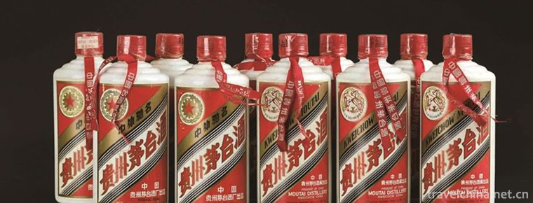
Maotai liquor brewing technology, the local traditional handicraft technology of Maotai Town, Zunyi City, Guizhou Province, is one of the national intangible cultural heritage..
Views: 157 Time 2019-05-29 -
Shaoxing opera
Shao Opera, a traditional Chinese opera. Originally known as "Shaoxing Chaotian Bomb", commonly known as "Shaoxing Daban", it originated from Qin Opera and was named Shaoxing Opera.
Views: 182 Time 2019-06-14 -
Beijing Institute of Fashion Technology
Beijing Garment College was founded in February 1959, formerly known as Beijing Textile Technology College. In July 1961, it was renamed Beijing Chemical Fiber Engineering College. It was a key univer.
Views: 332 Time 2019-09-06 -
Mianzhu Hanwang earthquake site
Mianzhu Hanwang earthquake site (Park) is composed of three areas: Dongqi factory area, Dongqi dormitory area and Hanwang town area. It mainly focuses on four themes: digital display platform.
Views: 211 Time 2020-11-05 -
Donghekou earthquake site park
Donghekou earthquake site park, located in Qingchuan County, Guangyuan City, Sichuan Province, is the first earthquake site protection memorial site of Wenchuan earthquake. On November 12, 2008, the opening ceremony and the launching ceremony of the tourism market after the earthquake were held..
Views: 231 Time 2020-11-08 -
Modern cheongsam
At the beginning of the 20th century, it was popular to wear a short jacket with trumpet shaped wide sleeves inside, and a long waistcoat without sleeves with the front and back of the coat reaching the ground. Since then, cheongsam has made some changes in the edge, sleeve.
Views: 116 Time 2020-12-11 -
Dazhou landform
The terrain of Dazhou city is high in the Northeast (Daba Mountain Area) and low in the Southwest (Basin hilly area). The highest point is datuanbao, Jichang Township, Xuanhan County, with an altitude of 2458.3 meters; the lowest is Tianguan village, Wan.
Views: 109 Time 2020-12-20 -
Dazhou hydrology
The rivers in Dazhou city mainly belong to the Jialing River water system, which is a tributary of the Yangtze River. It originates from Daba Mountain and distributes in the form of branches from north to south. Qianhe River, Zhonghe River and Houhe Riv.
Views: 170 Time 2020-12-20
