Gesara Ecotourism Scenic Area
Gesara Ecotourism Scenic Area
Gesala Ecotourism Area is located in Yankou Township, Waluo Township, Hot Spring Township and Qinghe Township in the northwest of Yanbian County, Panzhihua City. It is located at the junction of Sichuan and Yunnan Provinces. It is adjacent to Guosheng Township in Yanbian County in the east, Huaping County in Lijiang City, Yunnan Province in the South and west, and Yanyuan County in Liangshan Prefecture in the north. Geographical coordinates are 101 degrees 07'57 to 101 degrees 25'54 in the East and 26 degrees 53'30 to 27 degrees 12'40 in the north.
The landscape of the scenic spot is composed of Tiankeng ground leakage, karst landscape, alpine meadow and Yijia customs. The main scenic spot is 116 kilometers away from Lugu Lake and 376 kilometers away from Lijiang River. It can reach Daocheng and Aden along the 216 provincial road (rice climbing road). In 2003, the first Panxi (Yanbian) Ecotourism Festival was held in Gesala Township.
Geographical characteristics
Gesara Ecotourism Area covers an area of 594.23KM, with diverse vegetation and rich biology. The main natural landscapes are rhododendron, primitive forest, natural gardens, bonsai of the earth and the heavenly pits and drains, magnificent heavenly stone forests, fantastic underground caves, rolling alpine meadows, together with multi-ethnic cultural customs and beautiful legends, with magnificent ecological communities, extensive and profound national culture, gathering ecological tourism, national culture. Cultural sightseeing, adventure hunting and folklore are integrated into a unique scenic spot of eco-tourism and cultural tourism.
In 2001, this area has been included in the tourism development plan of Yanbian County. It has been developed as an eco-tourism area. In June 2003, as a key tourism development project of the whole city, the Municipal Tourism Bureau has signed a planning contract with Sichuan Tourism Planning and Design Institute. It is expected to start a high starting point, high standards and large-scale development and construction in 2004.
The Yi language "Gesara" refers to "the beautiful paradise where man and nature live in harmony". Commonly known as: the best place to play. Gesala Ecotourism Area has obvious advantages in location and convenient transportation. It is located at the junction of Yanbian County of Panzhihua, Yanyuan County of Liangshan Prefecture of Sichuan Province and Huaping County of Lijiang City of Yunnan Province. Provincial Highway 216 runs through Yankou Township from south to north. From Yankou Township to the west, there is a mechanized cultivation road leading to Huaping County, Lijiang City, Yunnan Province. The government of Yankou Township is located 118 km southeast to Panzhihua City, 36 km away from Ertan Reservoir Lake and 116 km north to Lugu Lake, shortening the distance from Xichang to Lugu Lake by nearly 89 km. From the point of view of location, Gesara Eco-tourism Area can not only become the tourism support center of Panxi Rift Valley Scenic Area, but also become an important tourism support point on Panzhihua-Lugu Lake Tourist Quality Line. As an important part of Panxi Great Rift Valley Tourism Area, Gesara Ecotourism Area has a variety of Natural Ecotourism Resources with distinctive characteristics and high grade. At the same time, the area is also a gathering area of the Yi people, with a strong Yi customs. In the ecotourism area, the terrain is complex, the mountains and valleys are deep, the vegetation is abundant, the biodiversity is obvious, and the species of wild animals and plants are rich, especially in 10,000 mu.
The ingenious combination of rhododendron, Pansong bamboo forest, alpine meadow and Yi people's customs constitutes a fantastic picture scroll of the Grand Rift Valley scenery. In addition, the breathtaking and varied geological wonders and the heavenly pits and drains, the quiet primitive forests, the Yi villages and ancient legends and other human resources fully show the unique charm of the natural ecology and humanistic ecotourism value of Gesala Ecotourism Area.
Climatic characteristics
Gesara Ecotourism Area has the characteristics of subtropical three-dimensional climate. Vertical zonal climate change is obvious due to the relatively high difference between the above and below rock areas.
The climate of Yanshan area is in the middle and north temperate zone. The average annual temperature is 9.0-11.2 C, the average temperature in the hottest month (June-July) is 15.0-17.1 C, and the average temperature in the coldest month (January) is 0.6-2.8 C. Yanshan area is a rainy area in Yanbian County, with annual rainfall of about 1600 mm and annual evaporation of 600-700 mm. It is a good place for summer and winter snow appreciation. The sub-rock area has the climate of the middle subtropical zone, the north subtropical zone and the south temperate zone. The average annual temperature is 11.8-17.3 C, the average temperature in the hottest month (June-July) is 17.7-23.0 C, and the average temperature in the coldest month (January) is 3.3-8.6 C. The annual rainfall is about 1480-1500mm and the annual evaporation is 800-1100mm. The rivers in the tourist area belong to the Yalong River system, a tributary of Jinsha River. Because it is located in the carbonate rock area, the underground river is well developed. The length of the underground river in Yankou is about 15 km, which forms a huge underground reservoir with a catchment of 40 million cubic meters.
natural resources
Gesara Eco-tourism Area is one of the important forest areas in Panzhihua City. The forest area is 34430.7hm2, and the forest coverage rate is 68.68%. Within the range of 500 square kilometers, there are patches of forests, shrubs, mountain dwarf forests and subalpine meadows. Species are diverse, including Pinus yunnanensis, Pinus armandii, Taxus yunnanensis, hemlock, spruce, fir, Pinus terrestris, Rhododendron, Camellia, Quercus acutissima, Coca, Castanopsis kawakamii and so on. They form coniferous forest, coniferous-broad-leaved mixed forest, broad-leaved forest, shrub and sparse forest grassland. There are 10,000 mu of rhododendron, site pine forest, alpine cold arrow bamboo forest, subalpine meadow and other plant landscape, as well as forest musk deer, small panda, Sichuan mountain parrot, rhesus monkey, white bellied pheasant, big purple-breasted parrot, grey-headed parrot, sparrow eagle and other rare animals. Gesara is a green world, a zoo.
Main attractions
Rift topography
The landscape of the scenic spot is composed of Tiankeng ground leakage, karst landscape, alpine meadow and Yijia customs. Here, mountains are rolling, peaks and loops alternate, sometimes loess high slopes, sometimes dense jungle, tea flowers, geological and geomorphological changes are tremendous. A senior geologist once said that "the landscape here is comparable to that of Huanglong in Jiuzhai".
Tin pit floor drain
Within the range of more than 300 square kilometers in Yanbian rock mouth and depression, there are more than 1000 funnel groups with different diameters and depths. The funnel group has a larger area of about 5000 square meters, a depth of about 30 meters, and a small area of about 400 square meters with different depths.
Limestone cave
Tiandong No. 1 is particularly noticeable. Under the cliff of more than 200 meters, 10 seconds after throwing stones into the vertical cave, Fang heard the sound of water. It was about 155 meters deep. There were five caves of different sizes around them, such as Lingze Cave. The karst landscape in the cave was unique and novel, such as "Guanyin Dian", "Luohan Group", "Camel Peak", "Lion Mountain" and "Luohan Group".
Alpine meadow
Gesala Ecotourism Area;
Alpine meadows rise and fall, and low pines are powerful.
Tourism information
Ticket information
Children's height below 1.2 meters (excluding 1.2 meters) is exempted from tickets; elderly people over 70 years old are exempted from tickets.
Old people aged 60-69 (including 69) buy tickets at half price with old age card and ID card
Traffic information
The self-driving route of Gesala Ecotourism Area: Zhihua City - Yumen Town - Gesala Yi Township - Gesala Visitor Reception Center City 73 km to Yumen Town, Yumen Town to Gesala Yi Township 41 km, and Yi Township to Gesala Main Scenic Area 13 km. 216 Provincial Highway, the road is in good condition.
Bus routes in Gesala Ecotourism Area:
1: Airport - Panzhihua Airport - 160 - From Panzhihua Airport to downtown by airport bus or taxi, then to downtown by bus to Yumen, and then to Yanyuan by bus from Yumen.
2: Railway Station - Jinjiang Railway Station of Panzhihua City - 160 - From Jinjiang Railway Station, take Bus No. 64 to the Passenger Transport Center, and then take Yanyuan Bus to the Passenger Transport Center to reach our Gesala Visitor Reception Center.
3: Downtown - Bingcaogang Stadium - take a taxi from Bingcaogang Stadium to Yumen and take a bus or private taxi to our Gusara Visitor Reception Center at Yumen.
4: The passenger train route is the same. It boards half an hour from Panzhihua Park in Panzhihua urban area. The journey is about 4 hours and the fare is 33 yuan.
Historical culture
Gesara Ecotourism Area belongs to the western edge of Panxi Rift Valley in geotectonics. The basic process of tectonic evolution of Panxi Great Rift Valley is: dome-forming uplift in Late Paleozoic (Silurian-Devonian) accompanied by intrusion of basic, ultrabasic layered rock mass and small annular alkaline complex; late Permian continental crust rupture accompanied by large-scale eruption of Emeishan basalt, followed by intrusion or eruption of alkali (acid) A-type annular complex; fault depression and accumulation on both sides of Late Triassic rift belt. Huge thick molasses-like red sandy conglomerate formation; Jurassic-Cretaceous comprehensive depression with extensive deposition of fluvial-lacustrine red sandy mudstone; Late Cretaceous-Early Tertiary rift atrophy, which limited the deposition of gypsum-bearing sandy mudstone and marl in the lake basin; Late Tertiary, the strong Himalayan orogenic movement squeezed from west to east, and the rift closed and disappeared. Due to the differential uplift and subsidence of the Quaternary neotectonic movement, a cliff with a length of tens of kilometers has been formed along the Yankou-Wafa line, which divides the area into two major geomorphic units. The upper part of Xiyan is a high mountain and hilly plateau area with an elevation of 2600-3300 M. Tiankeng, ground leakage and karst caves are developed, which have a strange mountain scenery of the plateau. The lower part of Dongyan is a Zhongshan Canyon area with an elevation of 1500-2600 M. The main scenic spots are canyons and waterfalls.
Folk customs
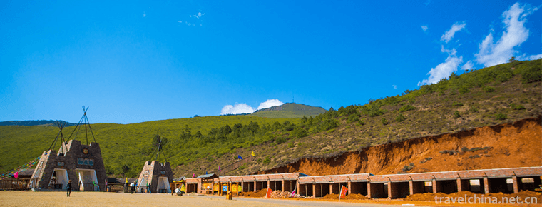
Folklore is full of the color of Yi nationality culture, where mountains rise into the clouds, and people of Yi nationality live with enthusiasm, simplicity and kindness. The primitive natural scenery is far away from the noise of the city and has not been destroyed artificially. The primitive folk customs have been continuing and spreading to this day. The peak circuit turns, the continuous grassland and the primitive forest are in line with the deep blue sky. When the azaleas blossom, here is the sea of flowers. Ami (young woman) of Yi nationality in gorgeous clothes dances and sings among the flowers. It is the perfect combination of human and nature.


-
Old Summer PalaceYuanmingyuan
No. 28 Qinghua West Road, Haidian District, Beijing, China.
Views: 115 Time 2018-10-03 -
Chill chicken rice noodles
Cold chicken noodles, Yunnan snacks, cold rice noodles with ....
Views: 269 Time 2018-10-17 -
Mount Song
Songshan, known as the "foreign side" in ancient times, Xia and Shang Dynasties as "lofty" and "Chongshan", Western Zhou Dynasty as "Yue Shan", Songshan as the .
Views: 187 Time 2018-10-30 -
Privacy Policy
We takes users' information safety and privacy as our lifeline. Based on our basic principle "Users' needs are our first priority", we are committed to enhancing the transparency of informat.
Views: 1664 Time 2018-12-08 -
Xiangshui lake the Great Wall
Xiangshui Lake is another unique and beautiful tourist attraction in the suburbs of Beijing. Located in the west of the Great Wall of Huairou Mutianyu.
Views: 443 Time 2018-12-10 -
Shibing Karst
Karst is karst. It is the general name of the geological function of water in dissolving rock (carbonate rock, gypsum, rock salt, etc.) mainly by chemical dissolution.
Views: 225 Time 2019-02-08 -
Imitated Diet Making Skills of Imperial Diet in Qing Dynasty
Imitated meals (imperial meals of the Qing Dynasty) production skills, Beijing Xicheng District local folk traditional skills, one of the national intangible cultural heritage..
Views: 290 Time 2019-04-29 -
Haha Opera
Haha Opera, also known as Liuzi Opera and Drinking Opera, is a local opera originated from the folk in Hebei Province. It is the first national intangible cultural heritage.
Views: 210 Time 2019-05-02 -
Dragon Boat rap
Dragon boat rap, also known as "Dragon Boat", "Dragon Boat Song", "Dragon Island Song" or "Shunde Dragon Boat", is a popular form of folk art in the Pearl River.
Views: 118 Time 2019-05-14 -
Gongs and drums
Gong and drum zaju, also known as "zaju of Gong and drum" and "long Yan zaju", is one of the local traditional dramas in Shanxi Province and Henan Province and one of the national .
Views: 118 Time 2019-05-15 -
Wenshui Tiaozi
Wenshui Biaozi is an ancient and unique traditional folk music art spread in Wenshui County, Shanxi Province. It is named for its special copper cymbals commonly known as "Biaozi" in perform.
Views: 144 Time 2019-06-29 -
Xiuyan Jade Carving
Xiuyan Jade Carving, one of the national intangible cultural heritage, is a local traditional art in Xiuyan Manchu Autonomous County, Liaoning Province..
Views: 116 Time 2019-07-08
