Three Parallel Rivers of Yunnan Protected Areas
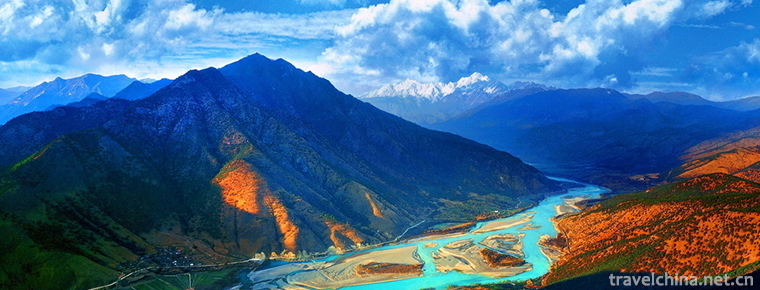
The three rivers running side by side are Jinsha River, Lancang River and Nujiang River, three rivers originating from the Qinghai-Tibet Plateau, running 170 kilometers from north to south in Yunnan Province, crossing the mountains of Danglika Mountain, Gaoligong Mountain, Nushan Mountain and Yunling Mountain. The upper part of the three parallel rivers is in southeastern Tibet and the lower part is in Yunnan Province.
It forms a peculiar natural and geographical landscape which is rare in the world, where rivers and rivers flow side by side but do not converge. The shortest straight line distance between Lancang River and Jinsha River is 66 kilometers, while the shortest straight line distance between Lancang River and Nujiang River is less than 19 kilometers.
The natural landscape of three parallel rivers is composed of Nujiang, Lancang, Jinsha rivers and mountain ranges in their basins, covering 1.7 million hectares. It includes 9 nature reserves and 10 scenic spots located in Lijiang, Diqing Tibetan Autonomous Prefecture, Nujiang Lisu Autonomous Prefecture in Yunnan Province. Located at the intersection of East Asia, South Asia and Qinghai-Tibet Plateau, it is a rare representative area of Alpine landform and its evolution in the world, and one of the most abundant areas of biological species in the world. The scenic spot spans Lijiang, Diqing Tibetan Autonomous Prefecture and Nujiang Lisu Autonomous Prefecture.
The three parallel rivers area is the richest geological and geomorphological Museum in the world. Forty million years ago, the collision between the Indian plate and the Eurasian plate triggered the sharp compression, uplift and cutting of the Hengduan Mountains. Alpine mountains and rivers alternately spread, forming the world's unique natural wonder of three rivers running 170 km parallel.
In 1988, with the approval of the State Council, "three rivers running side by side" was designated as the second batch of national scenic spots. In July 2003, according to the selection criteria of natural heritage, it was listed in the World Heritage List , and constructed the Three Rivers Parallel Nature Reserve (mainly the Three Rivers Parallel Nature Reserve in Yunnan Province).
Regional characteristics
1. The birthplace of the Tea-Horse Road
2. The Second largest World Heritage Site in China
3. The richest geological and geomorphological museums in the world
4. "World Biological Gene Bank", one of the most abundant areas of biological species in the world
5. Botanical circles call it "Natural Alpine Garden"
6. The rare alpine landforms in the world and the representative areas of their evolution
Geology and geomorphology
The "Three Rivers Parallel Flow" region is an outstanding representative of the main stages of the Earth's evolution, which reflects the rich and diverse geological relics, landscapes and geological phenomena, and shows the world the extremely complex history of crustal evolution and the ongoing geological role it has experienced.
The relatively complete paleobiostratigraphic records since the Late Paleozoic (400 million years ago) in the "Three Rivers Co-current" area reflect that the area was once a part of the vast Tethyan paleo-ocean, consisting of ultrabasic rocks (such as ophiolite, peridotite), basic rocks (such as gabbro, diabase, pillow basalt, spilite, etc.) and deep-sea deposits (such as radiolarian siliceous rocks). The composition of ophiolite reflects that this area was once similar to the present oceanic crust environment near the mid-oceanic ridge; the magmatic rocks (including volcanic rocks, hypabyssal rocks and plutonic rocks) of various types and compositions recorded the scale and characteristics of magmatic activities in different periods, reflecting the evolution model of different stages; the metamorphic rocks, melanges, tectonites and strata, rocks in this area. Structural deformations such as folds, faults, joints and cleavages in the rocks and deep and large fault systems between different blocks reflect the intense compressive activities that have been suffered here. Geological and historical processes such as the extinction of the oceanic crust, the compression of strata, the assemblage of blocks and the uplift of the crust have become clear in the interpretation of many information by geologists: "Three parallel rivers" area is the evolution and extinction of the Tethyan Ocean, the collision of the Indian plate and the Eurasian plate, the land-land collision between the two continents, and the orogenic movement has resulted in the formation of the Himalayan uplift and the Hengduan Mountains. Typical representative areas and key areas of geological evolution history.
In the history of the earth's evolution, the ocean always opens and closes in the crustal movement. The opening of the ocean will lead to the separation of land on both sides of the ocean crust, while the closure of the ocean will drive the convergence of land on both sides of the ocean crust. The Tethyan ocean has undergone different processes of opening and closing, leaving many geological traces of strata, rocks, fossils and crustal deformation that prove the process. The closure of the Tethys ocean eventually drives the Indian plate to rush towards the Eurasian plate, making the "three parallel rivers" region evolve from deep-sea ocean environment to oceanic island arc and multi-island oceanic basin environment, then to continental environment and plateau environment. The strong compression of the two continents crushes, crumples and metamorphoses the rocks here, and triggers large-scale magmatic activities. Continuous collision activities have caused large-scale uplift and strong tectonic deformation in this area, resulting in the formation of the world's most compacted and narrowest compression of the giant Hengduanshan composite orogenic belt, that is, the unique "three rivers parallel flow" spectacle in the world.
Various and complex geological and tectonic settings have laid the foundation for the formation of various geomorphological types in the "Three Rivers Parallel Current" area. The tall folded mountain systems and fault-block activities control the dynamic geology of the surface, erosion moulding of rivers, erosion of mountain glaciers, and carve out deep canyons, glacial valleys, glacial lakes, waterfalls, corner peaks, fin ridges, peaks and cliffs, creating the geological and geomorphological landscape areas with the world's first-rate aesthetic feeling. The typical landscapes of "Three Rivers Parallel Flow" include "Three Rivers Parallel Flow" spectacle composed of alpine canyons, glacial relics and modern glacial landscapes, alpine Danxia landscapes, granite peak cluster landscapes, Alpine karst landscapes and plateau, snow mountains, meadows, Alpine glacial erosion lakes and so on.
Complex, diverse and special geological evolution history, geological landform and geographic environment characteristics control the origin of primitive biological population and the distribution characteristics of hydrothermal conditions in the "Three Rivers Parallel Flow" area, and then control the biological evolution process, characteristics and evolution model, forming a diverse biological and ecological landscape.
The diverse rock types, geological structures and landscapes of the "Three Rivers Parallel Flow" provide typical traces for the interpretation of the important historical stages and important geological events of the Earth's evolution, such as the extinction of the Tethys ocean, the collision mechanism and model between the Indian plate and the Eurasian plate, the formation of the intracontinental mega-composite orogenic belt, the evolution and uplift of the Qinghai-Tibet Plateau, and show the ongoing process. The magnificent processes of topographic and geomorphological shaping, such as various dynamic and glacial geological processes, are the outstanding development areas of various types of Alpine landscapes and their evolutionary processes. These precious and rare geological and geomorphological landscapes and relics are the common wealth left by nature to mankind, and have very important world significance and protection value.
This region is of great value in showing the geological history associated with the collision of the Indian Ocean plate and Eurasian plate over the last 50 million years, the closure of the Paleo-Mediterranean and the uplift of the Himalayas and Tibetan Plateau. These are major geological events for the evolution of the Asian continent's surface and the changes that are taking place. The diversity of rock types in this region records this history, and karst topography, granite monoliths and Danxia sandstone topography in the alpine belt cover some of the best mountain types in the world.
The exciting ecological processes in the three parallel rivers region are the result of geological, climatic and topographic influences. Firstly, the region is located in the active area of crustal movement, resulting in a variety of rock beds, ranging from igneous rocks to various sedimentary rocks (including limestone, sandstone and conglomerate). Excellent geomorphology: from canyons to karst landforms to ice peaks, this wide range of landforms is related to the collision point of crustal tectonic plates. Another fact is that the area is a Pleistocene reserve for remnants and is located in a biogeographic convergence area (i.e., with mild climate and tropical elements), which provides a good physical basis for the evolution of high biodiversity. In addition to topographic diversity (with a nearly vertical steep slope of 6,000 meters), the monsoon climate affects most of the region, thus providing another favorable ecological factor for the good development of temperate biota in various Palaearctic regions.
natural resources
"Three rivers flow side by side" area is known as "the world biological gene bank". This area accounts for less than 0.4% of China's territory, but it has more than 20% of the higher plants and 25% of the national animal species. National Protected Animals
77 species of rare and endangered animals, including Yunnan snub monkey, antelope, snow leopard, Bengal tiger and black-necked crane
National Protected Plants
Thirty-four species of Taiwania flousiana, Phyllostachys chinensis, Taxus chinensis, etc.
Diversity
China and important regions in the Northern Hemisphere. 2\ 3 of the fauna in the nominated area belongs to endemic fauna or to the Himalayan-Hengduan fauna. The region is thought to have more than 25% of China's animal species, many of which are relic communities and endangered species. Many of China's rare and endangered animals live within the scope of the nominated areas. Among them, 80 species are listed in the Red Paper of Chinese Animals, 20 of which are considered endangered; 79 species are listed in the appendix to the 1997 Convention on International Trade in Endangered Species of Wild Fauna and Flora (CITES); and 57 species are listed in the appendix to the International Convention on the Protection of Nature and Natural Resources. IUCN's Red Paper on World Endangered Animals. Near the borders of the biogeographic regions of East Asia, Southeast Asia and Tibet, this region also provides a corridor for many species in each region to satisfy and reach their respective distribution boundaries. Most of the rare and endangered animals live in the western part of the region, especially in the narrow and long Gaoligong Mountains on the border of Myanmar and the Yunling Mountains between the Lancang and Jinsha Rivers.
Discovery process
In the 40 years from 1911 to 1950, F. Kingdon Ward, a British botanist and geographer, visited eight dangerous and difficult-to-reach secret lands in southeastern Tibet, northwest Yunnan and southwestern Sichuan. From April 1913 to March of the following year, Jindun Ward traveled through the three river basins of Jinsha, Lancang and Nujiang in the Hengduan Mountains bordering Sichuan, Yunnan and Tibet to investigate the river ownership, river system development, geology and geomorphology. He estimated that the ratio of annual runoff of Jinsha River, Lancang River and Nujiang River was roughly 5:3:2, and measured the distance between the three rivers below the "S" -shaped meander of Yuqu River. From the Nu River to the Jinsha River, the minimum distance was only 80.5 kilometers, making him the first person to discover the world's great geographic wonder that three great rivers parallel to each other in this section.
regional tourism
Summary
The natural landscape of "Three Rivers Parallel Flow" is located in the Longitudinal Valley of Hengduan Mountains in the southern extension of the Qinghai-Tibet Plateau. It consists of Nu River, Lancang River, Jinsha River and the mountain ranges in the basin. The whole area reaches 41,000 square kilometers. There are three scenic spots such as Nu River, Dulong River, Lancang River and Jinsha River, eight central scenic spots and more than 60 scenic spots, covering an area of more than 3500 square kilometers. The three rivers run parallel hundreds of kilometers in the longitudinal valley of Hengduan Mountains in Northwest Yunnan. The nearest straight line between the three rivers is 66.3 kilometers, of which only 18.6 kilometers are separated from the Nu and Lancang rivers.
Alpine snow peaks in the scenic area stretch across, and elevation varies vertically. From the 760-meter Nujiang dry-hot valley to the 6740-meter Kawagbo peak, there are snow mountains, primitive forests and ice-eroded lakes in the scenic area with different shapes. The main peak of Meili Snow Mountain, Kawagbo, is covered with glaciers for thousands of years. The glittering glaciers extend from the peak to the forest zone of Mingyong Village. It is the most spectacular and rare low latitude and low altitude monsoon oceanic modern glacier in the world.
The main landscapes are: peculiar "three rivers" flow side by side, magnificent mountains and snow peaks, dangerous canyons and beaches, beautiful forest, sea and snow plains, quiet ice-eroded lakes, rare plate collisions, vast snowy mountains and flowers, rich rare animals and plants, magnificent Baishuitai, unique national customs, which constitute the characteristics of majesty, danger, beauty, wonder, seclusion, Austria and sigh.
It is the largest area in Yunnan Province, with the richest landscape and colorful ethnic customs. It is a fascinating but undeveloped scenic spot. It was designated by UNESCO and approved by the State Council in 1988 as the second batch of national key scenic spots.
geological structure
The collision between the Indian plate and the Eurasian plate caused the uplift of the Qinghai-Tibet Plateau, which constituted the main body of the Hengduan Mountains formed by the huge mountains such as Dulong River, Gaoligong Mountain, Nujiang River, Lancang River, Yunling River, Jinshajiang River and the great rivers within 150 kilometers. This is the unique mountain gorge in the world. Valley natural landscape. From the geodetic evolution of ophiolites, pillow lavas, geological strata records from biochemical to Quaternary to the metamorphic and deformed Glacial Snow peaks of intracontinental orogenic belts, cave rivers, karst landforms and so on, they fully meet one of the criteria for the nomination of the World Natural Heritage.
The three rivers run parallel and flow about 170 kilometers in Yunnan Province. They are located in Lijiang, Diqing Tibetan Autonomous Prefecture and Nujiang Lisu Autonomous Prefecture in the western part of Yunnan Province, with a total area of 40,000 square kilometers. The shortest straight line distance between Nu River and Lancang River is only 18.6 kilometers, while the shortest straight line distance between Lancang River and Jinsha River is only 66.3 kilometers.
The Jinsha River goes from north to east, bringing together the Yalong River, Minjiang River and Jialing River, so China has the Yangtze River.
The Lancang River flows slowly from north to south, crossing the border and becoming the upper reaches of the neighbouring Mekong River.
The Nu River rushes from north to south into Myanmar and becomes the upstream of the Salwin River.
The three rivers originated from the Qinghai-Tibet Plateau. They are running hand in hand in the mountains of Yunnan.
The Jinsha River, through Shigu Town's Tianjiao wonder (the first bay of the Yangtze River), turns sharply back to the east of the Yangtze River and finally flows into the Pacific Ocean.
The Lancang River flows through Myanmar, Laos, Thailand, Cambodia and Vietnam and eventually into the Pacific Ocean.
The Nu River flows into Myanmar and into the Indian Ocean.
value and significance
The three parallel rivers region contains almost the whole scenery of Northwest Yunnan, among which the most recommended areas are Gaoligong Mountain, Meili Snow Mountain, Haba Snow Mountain, Qianhu Mountain, Hongshan, Yunling, Laojunshan and Laowoshan.
Gaoligong Mountains is a concentrated exhibition area of plant species diversity in the "three rivers parallel flow" region. It is the most well-preserved area in China and even in East Asia. It is also the most abundant area of endemic plant groups.
Meili Snow Mountains is not only the typical geomorphological features and rich geological relics of Lancang River Basin, but also the original habitat of Yunnan snub monkey, the flagship species of "three rivers flow side by side". Haba Snow Mountain has the most southern latitude of modern marine glaciers, Jinsha River Basin typical complete Alpine vertical natural landscape. Qianhu Mountain has unique landscape value of plateau forest lakes. Qianhu Mountain scenic spot has complete and unique alpine ecosystem diversity, alpine meadow, Azalea Forest and spruce fir forest are the most distinctive. Rare animals and plants such as Rhododendron cuckoo and Black-necked Crane inhabit it, which is one of the areas where plateau biodiversity is concentrated in the "three rivers parallel" region. Yunling area is located between Lancang River and its tributary Dianhe River in Lanping County of Nujiang River. The Yunnan Provincial Nature Reserve is under construction, which mainly protects the wild animals and their habitats represented by Yunnan Rhinopithecus yunnanensis.
Laojun mountain area mainly includes the typical landscape types of "plateau ice erosion Lake group" in Jinsha River basin, such as Alpine Rhododendron forest, glacier cave landform, alpine meadow pasture and alpine Danxia landform. Among them, "Dawn Dawn Danxia Landform Area" is a typical representative. The main scenic spots in Laohua Mountain include Xinhua Lake, Laohua Mountain Alpine Glacial Lake Group, Laluo River, Hongyan Cave Karst Cave, Lidiping Wild Flowers and so on, the second branch of Lancang River.
In view of the huge protection area, complex terrain and changeable weather, it is suggested that self-driving trips in the three parallel rivers should be conducted on the premise of professional guidance and abundant preparation.
Main area
The three parallel rivers area is divided into the following eight main areas:
Red mountain area
It includes typical plateau planation, Alpine karst and other landforms with complete ancient glacier relics, rich plant ecosystems, plateau lakes and other landscape types. It is a typical exhibition area of landscape resources value of "three rivers parallel flow" World Heritage Nominated Sites. Among them, the geological landscape of Niru Nanbao Grassland and Xiaoxueshan Yakou Plateau is the most typical. Niru-Nanbao grassland concentrates the glacial erosion lake on the plateau, belonging to Duhu Lake, alpine meadow, foundation flow, Nanbao, hard-leaved evergreen broad-leaved forest ecosystem, ancient glacier relics (Nanbao), River Valley human settlement environment (Niru River) plateau spring waterfall (colorful waterfall) and other types of landscape resources with large scope and concentrated distribution, which are primitive with extremely high protection value and development potential. Landscape Resources Research Exhibition area. At the same time, Nanbao River's ancient glacial landform remains are the most complete and concentrated glacial geological relics in the nominated area.
Qian Hu mountain area
Located in the local area of Xiaozhongdian Township in Shangri-la County, Diqing Prefecture, including Xiaozhongdian Township and Shangjiang Township, it is one of the concentrated exhibition areas of original vegetation and plateau lakes in Jinsha River Basin.
The Qianhu Mountains are covered with alpine glacial lakes. According to incomplete statistics, there are more than 100 plateau lakes of different sizes. Among them, Bigutianchi and Sanbihai are the representatives. It has unique landscape value of plateau forest lake.
Yunling District
Located in Lanping County of Nujiang River between Lancang River and its tributary Dianhe River.
According to the survey, there are four groups of Yunnan snub-nosed monkeys inhabiting the reserve, accounting for about 10% of the total number of Yunnan snub-nosed monkeys from 1500 to 2000. This may be the southernmost population of Yunnan snub-nosed monkey, which is one of my specialties. It has very important protection value. The forest coverage rate of the reserve is as high as 76%, most of which remain primitive and have abundant biodiversity. According to preliminary investigation, 28 species of mammals belonging to 7 orders and 13 families were recorded.
Lao Jun Mountain Area
The three parallel rivers area is the downstream of Jinsha River basin within the scope of "three parallel rivers". It mainly includes the "plateau ice erosion Lake group" of Jinsha River basin. As the nominated area of "three parallel rivers", Dawn Dawn Danxia Landform Area is a typical concentrated development area of alpine Danxia Landform and a demonstration area of demonstration and standardized protection and management of Jinsha River Basin scenic spots, which has typical representativeness. In Jinsi Factory, around the plateau lake near Ninety-nine Longtan, there is a pure Rhododendron forest ecosystem at an altitude of more than 3200 meters. There are up to 100 species of rhododendron, which is the most abundant distribution area of Rhododendron species in Jinsha River Basin. Rhododendron forest and mountain lakes together constitute a wonderful landscape scroll. Laojun Mountain in Lijiang distributes the largest and most complete Danxia landform in China. It is embedded in the evergreen bushes of the mangy primitive forest, which is brilliant and dazzling. There are many red rock surface weathering to form a tortoise-like structure, one of the hillsides like tens of millions of small turtles and a large turtle, arranged naturally and orderly, as if moving towards the east of the rising sun.
Lao Mountain Area
Located in the lower reaches of the Lancang River Basin, Diqing Tibetan Autonomous Prefecture, Weixi Lisu Autonomous County, Zhongchou and Weideng Township on the West Bank of the Lancang River are supplementary areas of landscape resources in the Lancang River Basin, focusing on the protection of alpine lakes, plateau meadows and wild flower resources. The main scenic spots include Xinhua Lake, Laowushan Alpine glacial lakes, Laluo River, Hongyan Cave Karst, the second branch of the Lancang River. The wild flowers in Dongdong and Lidiping are still in the original undeveloped stage.
Gaoligong Mountain Area
A centralized exhibition area of plant species diversity in the "Three Rivers Parallel" region. Among them, the evergreen broad-leaved forest extending from east to west, which was listed by the Committee on Biological Diversity of the Chinese Academy of Sciences as "the key area of terrestrial biodiversity with world significance" and "the origin of important type specimens". Here, it is a museum showing typical geomorphological features of Nujiang River basin, including the geological landscape of deep river meanders of Nujiang River represented by the First Bay of Nujiang River and its surrounding areas. The Stone Moon Scenic Spot is a typical representative of the karst cave landscape of high mountains in Nujiang River basin. Gaoligong Mountain Nature Reserve is the largest nature reserve within the scope of World Heritage nominations.
Meili Snow Mountain Area
There are typical geomorphological features and rich geological relics in Lancang River Basin, and it is also the original habitat of Yunnan snub-nosed monkey, the flagship species of "three rivers flow side by side".
In the Yunnan-Tibet highway extension and its surrounding areas across the reserve, a large number of ancient deep-sea oceanic geology, biological relics and glaciers, orogenic relics and extensive glacier and frozen land physiognomy development are preserved, which is a relatively concentrated geological heritage exhibition area for the "Three Rivers Parallel" World Heritage Nomination Site. Yunnan snub-nosed monkey is the most typical flagship species in the "three parallel rivers" region, and Baimangshan Snow Mountain Nature Reserve is the most concentrated one.
Mt. Kawagbo, the main peak of Mt. Meri Snow Mountain, is 6740 meters above sea level. It is the highest peak in the nominated area. Nobody has reached the summit successfully because of its unique topographic and climatic factors. Tibetan Buddhism has a strong religious color. The Mingyong Glacier, located at Kawagbo Peak, extends its tongue to 2650 meters above sea level. The surrounding green hills, conifers and broad-leaved mixed wet evergreen broad-leaved forest is well preserved, which represents the typical diversity of the Lancang River dry-hot valley. At present, it is the lowest glacier in the northern hemisphere and one of the lowest latitude glaciers.
Haba Snow Mountain Area
The area has the most southern latitude of modern marine glaciers, Jinsha River basin typical complete Alpine vertical natural landscape. Within a very small space, the vegetation types from subtropical dry and warm valleys to alpine and cold zones are concentrated. Cold-temperate coniferous forest is the most important ecosystem type in mountain ecosystem of Haba Snow Mountain Nature Reserve. It is characterized by rich and complex Chinese-Himalayan elements, and is the most typical Alpine coniferous forest reserve area of "World Heritage Nomination Site".
The main peak of Haba Snow Mountain is 5396 meters above sea level, which is one of the most famous extremely high mountains in Yunnan. There are modern glaciers on the top of the mountain. Like the glaciers in Yulong Snow Mountain, it is also the southernmost oceanic glacier in China. Alpine moraine lakes (Black Sea, Yellow Lake and Bay Sea) reflect the glacial relics formed by the accumulation of water in ancient ice buckets during the Dali Glaciation Period, and are the only "Dali Glaciation Period" glacial relics distribution area in the "Three Rivers Parallel Current" nomination site.
Application process
In 1988, the State Council approved the establishment of the "Three Rivers Parallel" National Key Scenic Spots; in 1993, the "Three Rivers Parallel" was officially listed in the preparatory list for China's declaration of world heritage; in 1998, the Yunnan Provincial Government put forward the strategy of "building a strong green economy province, a major national and cultural province, and connecting China with Southeast Asia through the creation of the world". Heritage brand promotes the development of Yunnan's tourism industry and decides to speed up the progress of applying for World Heritage by "three rivers running side by side". In that year, with the consent of the provincial Party Committee and the provincial government, the Yunnan Provincial Construction Department formally submitted applications to the UNESCO Committee and the Ministry of National Construction of China. The application for declaration has been supported and Yunnan Province has been approved to formally carry out the declaration work. On January 17, 2002, with the signature and approval of Li Lanqing, Wen Jiabao and Qian Qichen, the former Vice Premier of the State Council, the full committee of UNESCO, the Ministry of Foreign Affairs and the Ministry of Construction of China jointly issued a document agreeing that "three rivers flow side by side" would become the only declared project of World Heritage in China and be officially submitted to the UNESCO World Heritage Center.
From October 8 to 20, 2002, experts from the International Union for the Conservation of Nature (IUCN) made a field trip to the "three rivers parallel" area in Yunnan Province. In June 2003, the alliance recommended to the United Nations World Heritage Committee that "three rivers flow side by side" be included in the World Heritage List according to the four criteria of meeting all the World Natural Heritage Sites.
Scenic spot protection
In July 2018, the People's Government of Yunnan Province promulgated "Several Provisions on Strengthening the Protection and Management of World Natural Heritage Sites with Three Rivers in Parallel Flow in Yunnan Province", which will accelerate the ecological environment protection of the World Natural Heritage Sites with Three Rivers in Parallel Flow. The people's governments of the prefectures, cities, counties and districts where the three rivers are located should strictly control the intensity of development within the heritage sites and prevent In the heritage sites with three parallel rivers, construction of other engineering facilities is strictly prohibited except for the necessary protection facilities and public service facilities.


-
Panlongxia Ecotourism Area
Panlongxia Ecotourism Area is located in the northwest of Deqing County, Guangdong Province, about 28 kilometers away from the county seat. The whole ecotourism area covers an area of 30,000 mu.
Views: 151 Time 2019-02-07 -
Wangcheng in heaven
Tianwangcheng Scenic Area is located 40 kilometers northwest of Yishui County, Linyi City, Shandong Province. The main part of the Scenic Area is located in Jiwanggu. It is the national AAAA scenic sp.
Views: 101 Time 2019-02-21 -
Zhijin cave
Zhijin Cave, located in Guanzhai Miao Township, Zhijin County, Guizhou Province, is located on the South Bank of Liuchong River, one of the sources of Wujiang River, 120 kilometers away from Guiyang, .
Views: 138 Time 2019-03-18 -
Emei Chito
"A Mei Qituo" is the original ecological dance name of a group of Yi people. It is translated as "Girl Marriage Dance" in Chinese and originated from Sanbao Yi Township in Qinglong.
Views: 183 Time 2019-03-28 -
Hubei storytelling
The evaluation of books in Hubei Province is a traditional art of rap and singing in Hubei Province. Popular in northern China, as an independent variety of storytelling,.
Views: 172 Time 2019-05-03 -
The technical skill of penjing
Bonsai art refers to the Soviet bonsai art, which originated in the Tang Dynasty, flourished in the Ming Dynasty, matured in the Qing Dynasty, and developed in modern times. Since the 1980s, Suzhou Bo.
Views: 236 Time 2019-06-09 -
Pipa Art
In the history of modern Chinese traditional folk music, there are two schools of pipa: the "Shanghai School" (Pudong School) and the "Zhejiang School" (Pinghu School). The Pipa ar.
Views: 102 Time 2019-06-09 -
Qiyang minor
Qiyang in the north of Yongzhou is a kind of traditional opera widely spread. After a long period of evolution and development, it has formed a traditional folk art form with strong local color,.
Views: 133 Time 2019-06-10 -
Suzhou embroidery
Suzhou embroidery is the general name of embroidery products in Suzhou area. Its origin is in Wuxian, Suzhou. Now it has spread all over Wuxi, Changzhou and other places. Embroidery and silkworm reari.
Views: 121 Time 2019-06-17 -
Acupuncture
Acupuncture means that under the guidance of traditional Chinese medicine theory, needles (usually filiform needles) are punctured into patients'bodies at a certain angle, and needling techniques such.
Views: 109 Time 2019-07-25 -
Southwest Medical University
Southwest Medical University is an ordinary university in Sichuan Province. It is located in Luzhou, a famous historical and cultural city and a civilized city in the region of Sichuan, Yunnan, Guizho.
Views: 121 Time 2019-08-31 -
Beijing Union University
Beijing Union University was founded in 1985 by the Ministry of education. It is a comprehensive university in Beijing. Its predecessor was the 36 University branches in Beijing in 1978. After more th.
Views: 159 Time 2019-09-06
