Huanglong Scenic Area
Huanglong Scenic Spot, World Natural Heritage, World Human and Biosphere Reserve, Green Globe 21 Certificate, National AAAAA Tourist Spot, National Key Scenic Spot.
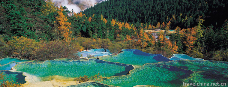
Huanglong is located in Songpan County, Aba Tibetan and Qiang Autonomous Prefecture, Sichuan Province. It is the only well-protected plateau wetland in China. It is 100 kilometers away from Jiuzhaigou and 1700-5588 meters above sea level. Its geomorphological features are steep gorges. Because there are many color pools in the ditch, with the change of surrounding scenery and the change of sunshine angle, they change into colorful colors, which are known as "human Yao Chi".
Huanglong is famous for its "Four Wonders" of colorful pools, snow mountains, canyons and forests. In addition, Tanliu, ancient temples and folk customs are called "Seven Wonders". The scenic spot consists of Huanglonggou, Danyun Gorge, Munigou, Xueboding, Xueshan Liang, Hongxingyan, Xigou and other scenic spots. The main scenic spot is Huanglonggou, which is located under Xuebaoding, the main peak of Minshan Mountains. It faces the source of Fujiang River and resembles the image of "dragon" in the eyes of the Chinese people. Therefore, it has always been called the "symbol of China".
Huanglong is famous for its magnificent, exquisite and colourful travertine landscapes on the surface, and its rare karst landscapes at home and abroad. It can be called a fairyland on earth.
On October 9, 2016, the National Tourism Administration issued the "Red and Black List" for 11 holidays, and the Huanglong scenic spot was listed as the best scenic spot in the comprehensive order.
Name source
Huanglonggou, the main scenic spot, resembles the image of "dragon" in the mind of the Chinese people, so it has always been known as "the Yao Chi on earth" and "the symbol of China". Tibetans call it "Dongri Seljun", which means Conch Mountain in the East (referring to Xuebaoshan) and Golden Haizi (referring to Huanglonggou).
Development and construction
In October 1982, the State Council of the People's Republic of China approved Huanglong as a national key scenic spot.
In December 1992, Huanglong was officially listed in the World Heritage List as a natural heritage by UNESCO.
In 1997, it was listed as the world's human and biosphere reserve by the United Nations.
In February 2001, with the certificate of "Green Global 21", Huanglong has become a world-class scenic spot with three laureates.
geographical environment
Location territory
Huanglong Scenic Area is located in the southern part of the Minshan Mountains in Songpan County, Aba Tibetan and Qiang Autonomous Prefecture, northern Sichuan Province. It belongs to the transition zone from the eastern edge of the Qinghai-Tibet Plateau to the Sichuan Basin. Scenic spots range from 103 25 59 ~104 8 45, 32 30 53 ~32 54. The highest peak, Xuebaofeng, the main peak of Minshan Mountain, is 5588 meters above sea level. It is covered with snow all the year round. It is the easternmost point where modern glaciers exist in China. The total area is 700 square kilometers, and the outer protected area is 640 square kilometers.
Geology and geomorphology
The overall geomorphological characteristics of Huanglong area are mountains and gorges. It is characterized by forest-like corner peaks, vertically and horizontally edged ridges, deep canyons, steep cliffs, branched rivers, straight South and north. Huanglong's elevation ranges from 1700 to 5588 meters above sea level. Generally, the relative elevation difference between peak and valley is more than 1000 meters. Most of them are ice erosion landforms with great momentum and magnificence. Huanglong Dokarst Canyon is characterized by its changeable space, steep cliffs, abundant waterscape and lush vegetation. According to the shape of the bottom of the valley, there are Danyun karst River gorge, Zhaga travertine forest gorge and Erdaohai travertine Lake gorge. The source of Fujiang River in Huanglong territory is a main east-west tree-like River system. The upstream river bed is wide and flat, the downstream Canyon is deep, the South Branch is straight, and the North Branch is steep, forming a unique style of the source of Fujiang River.
Huanglong is at the junction of units in space. Tectonically, it is situated at the junction of Yangtze quasi-platform, Songpan-Ganzi fold system and Qinling geosynclinal folding system. Geomorphologically, it belongs to the front of China's second geomorphic ladder ridge, and the eastern margin of the Qinghai-Tibet Plateau and the western mountainous area of Sichuan Basin. In the scenic spot, there are also East-West Snow Mountain Fault, Huya Fault, Minshan Fault, Zhagashan Fault, and cross-cutting Fault. There are great differences in lithology, sequence, sediment and other palaeogeographic conditions, stratigraphic structure and structural features between Huanglong and Munigou Scenic Area.
Climatic characteristics
Huanglong Scenic Area belongs to the subtropical monsoon climate of plateau temperate zone. Climate characteristics are: wet and cold, long winter in a year, few days in summer, spring and autumn are linked. The annual average temperature is 7 C, the sunshine is abundant, the morning and evening fog is abundant, and the rainfall mostly concentrates in May to August every year. The annual average temperature of Huanglong Scenic Area is 5-7 C, the hottest July average temperature is 17 C, and the coldest January average temperature is 3 C. April-November is the best time to visit Huanglong every year.
Huanglong Valley
Located at Xuebaoding, the main peak of Minshan Mountain, next to Fujiang River, Fuyuan Bridge, is a gentle slope Valley 7.5 kilometers long and 1.5 kilometers wide. The ditch is covered with milky yellow rocks and looks like Huanglong, which is gently winding in the dense forest valley. The name of Huanglong ditch comes from this. In the Ming Dynasty (1368-1644 AD), Huanglong Temple was built here to worship Huanglong. Huanglonggou is famous at home and abroad for its "strange, unique, beautiful and secluded" natural scenery. It resembles the image of "dragon" in Chinese people's mind. Tibetans call it "East Japan-Sel Consultation", which means Conch Mountain in the East (referring to Xuebaoding) and Golden Haizi (referring to Huanglonggou). It also follows the annual grand occasion, which affects the people of all ethnic groups in northwest provinces and regions. Huanglonggou continuous distribution of calcification section up to 3600 meters, the longest calcified beach 1300 meters long, the widest 170 meters; the number of color pools up to 3400; the maximum of the Bianshi Dam up to 7.2 meters.
Welcome pool
Entering the Huanglong Scenic Area, the first thing you can see is a group of delicate and unique pools with bright water quality - Yingbin Pool. Pools of different sizes, strange shapes, brilliant colors, scattered in different places, surrounded by mountains, green trees, wild flowers in the mountains, butterflies flying. The winding stone paths in the mountains are embellished with scenic pavilions and pavilions, which add much interest.
Flying waterfall
Farewell to Yingbin Pool, winding up along the winding trestle road, you can see thousands of layers of blue water breaking through the dense forest, down the slope, flying down the rocky ridge about 10 meters high and 60 meters wide, forming dozens of trapezoidal waterfalls, such as pearls rolling down, silver glittering; such as water curtain hanging high, clouds and mists transpiring; such as silky slow flow, stretching and elegant; such as pearl curtain flashing, graceful and graceful. There is a precipice behind the waterfall, mostly horse lung and sheet calcification accumulation, drooping, golden color, making the whole waterfall look magnificent and spectacular. Through the sun's afterglow point dyeing, reflecting different colors, the distant view is like the rosy clouds falling from the sky, especially brilliant, known as "waterfall flowing brilliance".
Body wash hole
The body washing cave is 1273 meters away from Fuyuan Bridge and is located on the second step of Huanglonggou. The travertine flow falling from the golden beach suddenly collapsed here and fell into a travertine collapse wall 10 meters high and 40 meters wide. It is the longest travertine collapse wall in the world. The rushing water surges down the embankment and falls on the travertine wall to form a magnificent travertine waterfall. The body wash hole is located at the lower part of the travertine waterfall.
Bonsai Pool
The bonsai pool consists of a group of nearly 100 pools, with pools in the pool and pools coated with pools. The pool embankment changes with the tree's rhizome and topography, the bank is connected, the living water is of the same origin and cascades; the bottom of the pool is yellow, white, brown and grey in many colors, the surface of the pool is clean and dustless, looking like a mirror; the pool beside the pool is full of woods, stones, flowers, cypress, mountain flowers and wild fruits. This magnificent landscape, like the unique bonsai created by nature, makes gardeners amazed.
This landscape includes a mirror reflecting pool close to the forest, a Borneo colour pool hidden among azalea bushes and more than 500 colour pools with the richest colours in the calcified landscape.
Huanglong Temple
About 3.5 kilometers away from the mouth of the ditch, there is Huanglong Zhongsi Temple to allow visitors to rest. According to Songpan County Chronicle, "Huanglong Temple, built by the Ming soldiers and horses, is also known as Xueshan Temple. It is said that Huanglong's real people raised Taoism here, hence its name. There are three temples, front, middle and rear, facing each other, five miles apart.
There are three original temples in the ditch, including the former, the middle and the latter, and the former only remains. There are five temples in the ditch, covering an area of about 5100 square meters. The existing Guanyin Hall and ten statues of Luohan in the ditch are located at the end of Huanglonggou, 3558 meters above sea level, 2100 square meters. The temple buildings are basically well preserved. According to legend, Huanglong helped Yu to control water effectively, and later generations built monuments in this temple for sacrifice. Another is that Huanglong Temple was built because of the immortality of Huanglong Temple. In the main hall of the temple, there is a statue of Huanglong, who is wearing a black Taoist robe and has a serene look.
Munigou Scenic Area
Scenic spot landscape
Mounigou Scenic Area, located in the southwest of Songpan County, is a new scenic spot of Huanglong Scenic Area. It collects the beauty of Jiuzhaigou and Huanglong, but it is more primitive and clean, and there is no obstacle to freezing and sealing mountains in winter. Mountains, forests, caves and seas in the scenic area contrast to each other, and trees are everywhere. The size of Haizi can be comparable to the color pool in Jiuzhaigou, while the calcified pool waterfall can compete with Huanglong Yaochi.
Zaga Falls
In the primitive forest of Munigou Scenic Area, there is a huge flow of water from the 104-meter-high terraced travertine rock mass, roaring like a nine-day straight fall, with a spectacular momentum. It is the largest calcified waterfall in China, Zaga Falls. Zaga Falls is located at 3270 meters above sea level, 93.2 meters high and 35 meters wide. The upper reaches are lakes and the lower reaches are a series of stepped riverbeds. Hundreds of cascaded calcified annular waterfalls are connected in a series of beads, which fall down through three calcified steps and impact into huge calcified surface, forming huge white flowers with thunderous sound and sound. On the calcified wall of the second stage of the Great Falls, there is a "water curtain hole" with water flowing at the entrance of the cave and meteorological endlessness in the cave.
Splashing jade platform
Jade Splashing Platform is a circular platform. When the waterfall falls down from the top of the mountain, it falls on this platform. The waves splash like white jade. After a steep trestle, you can visit the viewing platform in the middle of the waterfall. Looking down from here is the "Jade Splashing Platform" where pearls splash jade. Leaving the viewing platform, the trestle began to steepen. After a period of mad waterfall, we reach the source of Zaga Falls.
hot-spring
Erdaohai is the northern part of Munigou Scenic Area, just one hill away from Zaga Falls. The name Erdaohai has a long history. It is said that it comes from two main lakes, Xiaohaizi and Dahaizi. "Songpan County Chronicle" also records: "Erdaohai, Songpan City West, after Ma'anshan, the two seas are connected like a human eye."
The Erdaohai Scenic Area is a narrow and long gully, which is 5 kilometers long and connected by a trestle road. From the camp along the trestle road, along the way, you can see Xiaohaizi, Dahaizi, Swan Lake, Jade Lake, Rhinoceros Lake and so on. They are like pearls and precious stones. Some are hidden in dense forests; others are exposed under the blue sky. The lake water is clear and transparent. The water surface is like a mirror. The green forest reflects the water. It is a clear and blue scene of the New Year. Summer and autumn season, the lake is full of white water flowers, flowers and seas are inseparable, very distinctive. The sea is connected by a trestle road, and the complex Pavilion adds a little wild interest to the sea.
Pearl Lake
Pearl Lake is also known as Boiled Pearl Lake. It is said that the Nine Days Fairy Boiled Pearl Fountain built here is a bathing pool for dispelling diseases. The water temperature here is relatively high, even in the severe winter when the snow is frozen, the water temperature is about 25 degrees Celsius. Sulphur smells strong at the edge of the pool. People often bathe here. It is said that it can cure skin diseases.
Red Star Rock
Xue Bao Ding
Xuebaoding is the main peak of Minshan Mountains. It is 5588 meters above sea level, 50 kilometers east of Songpan County.
Xuebaoding Mountain is covered with snow all the year round, with rocky hillsides, ravines and lakes. There are 108 larger Haizi, especially the four seas: the southeast round sea like a mirror, the southwest sea like a city, the northwest semi-circle sea like a crescent moon, and the Northeast triangle sea reflected by a pyramid. The foothills of Xuebaoding Mountain are covered with flowers and grass, shrubs and pines and cypresses. At this time, there are a large number of Fritillaria, Rhubarb, Snow Lotus and other valuable medicinal herbs, but also the habitat and reproduction of precious animals such as green sheep, mountain deer, Swertia roxburghii.
The west, north and south sides of Xuebaoding Peak are high cliffs, which make the climbers unable to do anything. Although the East and West slopes are relatively slow, they are also amazing. China and Japan climbed the cliff top in 1999. After investigation, it is believed that this is a famous mountain with infinite value in scientific research and development of sports undertakings.
Four ditch Scenic Area
Sigou Scenic Area is about 12 kilometers away from Huanglonggou, which is an open ancient glacier valley. The gully mouth area is a flat and open alluvial terrace, which is the ancient deep mountain town of Huanglong Township. The scenic area is 2700 - 4200 meters above sea level. The terrain is complex and changeable. It has not only strange peaks towering into the clouds, but also open river beaches. Primitive forests and glaciers, earthquake relics after hundreds of millions of years of vicissitudes and changes, still maintain the original appearance of the time, and the beautiful rural scenery is interesting. It's the nearest to Huanglonggou, but it has a completely different style.
The main natural landscape in the scenic area is the Quaternary glacial relics and the open-mouthed virgin forest. The source of the trench is composed of exotic ice erosion landforms and modern earthquake disaster landscapes. The huge mountain steps that suddenly collapsed and the rocky faults that rose violently were always astonishing.
In addition, there are alpine desert landscape in the ditch, which is similar to the "Gobi Beach" on the plateau. They are the remains of the strong Himalayan orogeny in ancient times. This is a paradise for science-loving and adventure-loving tourists.
The watershed is a vast alpine meadow pasture. Standing on the watershed, we can overlook the glacier barrier lake and the immense primitive forest at the source of Jiuzhaigou. In ancient times, the famous "Longan Road" in Northwest Sichuan passed through here, so there are still wide roads in the ditch. In the past few years of 2009, tourists have been getting off their bicycles and riding horses, or hiking ditches to enjoy the natural scenery of primitive forests and alpine meadow pastures.
Dan Yun Gorge
Danyun Gorge, with its beautiful scenery of Junxiuyin Gorge, has become one of the "five wonders" of Huanglong. It has abundant tree species, shrubs and flowers, and is a paradise for plant enthusiasts. The Yubamboo shoots cluster peaks in Danyunxia scenic spot stop at Fanzidong, which stretches 18.5 kilometers with a drop of 1300 meters and a height difference of 1000 to 2000 meters. Here is a snow-white winter, green mountains in summer, especially the red azaleas in spring and maple leaves in autumn all the way across the canyon. The scene is like a burning cloud falling from the sky under the setting sun. Danyun Gorge is named for it. Clouds grow in mountains and trees breeze in trees. Clouds and mists rise from the forest almost every day in Danyun Gorge. Clouds and mists shroud the mountains and appear from time to time. Danyun Gorge is densely forested, originating from Fujiang River on Xuebaoding. It is like a white dragon wagging its head and tail, which echoes the Yellow Dragon beside it.
Red Star Rock Scenic Area is characterized by a large number of exotic peaks and rocky landscapes formed by Quaternary glaciation and glacial barrier lakes, with rare human tracks and mysterious features. Red Star Rock Scenic Spot is located on the east side of Zhangla Basin and the west slope of Minshan Mountains. The scenic spot has a high elevation. It is characterized by a large number of exotic peaks and rocky landforms formed by Quaternary glaciation and glacial barrier lakes. It is rare and mysterious. Located in the "Red Star Sea" at 4300 meters above sea level, the lake is an asymmetrical pentagonal star, quiet and beautiful, surrounded by beautiful flowers. In the middle of the cliff, there is a red cave, which looks like blood, and its origin is unknown. When the wind blows and clouds surge, the cave is hidden in the clouds and mists. When the sun shines, there is a curly red light that breaks through the clouds and mists and appears from time to time. It is strange and fantastic.
Xue Bao Ding
Xuebaoding is the main peak of Minshan Mountains. It is 5588 meters above sea level, 50 kilometers east of Songpan County.
Xuebaoding Mountain is covered with snow all the year round, with rocky hillsides, ravines and lakes. There are 108 larger Haizi, especially the four seas: the southeast round sea like a mirror, the southwest sea like a city, the northwest semi-circle sea like a crescent moon, and the Northeast triangle sea reflected by a pyramid. The foothills of Xuebaoding Mountain are covered with flowers and grass, shrubs and pines and cypresses. At this time, there are a large number of Fritillaria, Rhubarb, Snow Lotus and other valuable medicinal herbs, but also the habitat and reproduction of precious animals such as green sheep, mountain deer, Swertia roxburghii.
The west, north and south sides of Xuebaoding Peak are high cliffs, which make the climbers unable to do anything. Although the East and West slopes are relatively slow, they are also amazing. China and Japan climbed the cliff top in 1999. After investigation, it is believed that this is a famous mountain with infinite value in scientific research and development of sports undertakings.
Four ditch Scenic Area
Sigou Scenic Area is about 12 kilometers away from Huanglonggou, which is an open ancient glacier valley. The gully mouth area is a flat and open alluvial terrace, which is the ancient deep mountain town of Huanglong Township. The scenic area is 2700 - 4200 meters above sea level. The terrain is complex and changeable. It has not only strange peaks towering into the clouds, but also open river beaches. Primitive forests and glaciers, earthquake relics after hundreds of millions of years of vicissitudes and changes, still maintain the original appearance of the time, and the beautiful rural scenery is interesting. It's the nearest to Huanglonggou, but it has a completely different style.
The main natural landscape in the scenic area is the Quaternary glacial relics and the open-mouthed virgin forest. The source of the trench is composed of exotic ice erosion landforms and modern earthquake disaster landscapes. The huge mountain steps that suddenly collapsed and the rocky faults that rose violently were always astonishing.
In addition, there are alpine desert landscape in the ditch, which is similar to the "Gobi Beach" on the plateau. They are the remains of the strong Himalayan orogeny in ancient times. This is a paradise for science-loving and adventure-loving tourists.
The watershed is a vast alpine meadow pasture. Standing on the watershed, we can overlook the glacier barrier lake and the immense primitive forest at the source of Jiuzhaigou. In ancient times, the famous "Longan Road" in Northwest Sichuan passed through here, so there are still wide roads in the ditch. In the past few years of 2009, tourists have been getting off their bicycles and riding horses, or hiking ditches to enjoy the natural scenery of primitive forests and alpine meadow pastures.
Dan Yun Gorge
Danyun Gorge, with its beautiful scenery of Junxiuyin Gorge, has become one of the "five wonders" of Huanglong. It has abundant tree species, shrubs and flowers, and is a paradise for plant enthusiasts. The Yubamboo shoots cluster peaks in Danyunxia scenic spot stop at Fanzidong, which stretches 18.5 kilometers with a drop of 1300 meters and a height difference of 1000 to 2000 meters. Here is a snow-white winter, green mountains in summer, especially the red azaleas in spring and maple leaves in autumn all the way across the canyon. The scene is like a burning cloud falling from the sky under the setting sun. Danyun Gorge is named for it. Clouds grow in mountains and trees breeze in trees. Clouds and mists rise from the forest almost every day in Danyun Gorge. Clouds and mists shroud the mountains and appear from time to time. Danyun Gorge is densely forested, originating from Fujiang River on Xuebaoding. It is like a white dragon wagging its head and tail, which echoes the Yellow Dragon beside it.
Tourism information
Reminder: Huanglong scenic spot above 3000 meters is one of the highest scenic spots in China. Tourists should be prepared to prevent plateau reaction when they come to travel. It is suggested that they take Hongjingtian or take Omo Oxygen Tablets with them seven days before going to Huanglong.
External traffic: Jiuhuang Airport, located in Chuanzhusi Town, is 43 kilometers away from Huanglong. During the tourist season (April-November), there are airport buses from the airport to Huanglong. After stopping for about 4 hours, they will leave for Jiuzhaigou with a ticket of 100 yuan per person. It can also take a bus from Xinnanmen Station in Chengdu to Huanglong, the whole second-class highway, the road condition is good.
The 0-distance plan covers the travel routes of Sichuan classic scenic spots such as Wolong, Huanglong, Jiuzhaigou, Conch Valley, Emei Mountain, Leshan, Dujiangyan, Qingcheng Mountain, Jianmen Shudao, Aden and so on.
Tickets: 190 yuan per person in peak season and 80 yuan per person in off season.
Cable car: 80 yuan per person up and 40 yuan per person down.


-
Three Gorges Dam
The Three Gorges Dam is located in Sandouping Town, Yichang City, Hubei Province, China. It is 38 kilometers from the Gezhouba .
Views: 146 Time 2018-11-11 -
Global Dinosaur City Scenic Spot
The National 5A Tourist Scenic Spot Global Dinosaur City, located in Xinbei District, Changzhou, Jiangsu Province, is a comprehensive tourism resort with dinosaur theme.
Views: 274 Time 2018-12-06 -
Chengji Mountain Tourist Scenic Spot
Qiu Mountain, also known as Linglong Mountain, Xianshan Mountain on a journey to the West and Qiu Mountain Scenic Area, is located in Suiping County, Zhumadian City, Henan Province.
Views: 128 Time 2018-12-09 -
Chuanlord Tourism & Leisure EXPO Park
Chuanlord Tourism & Leisure EXPO Park ,Changlu Tourism Xiubo Park, or Changlu Environmental Protection Holiday Farm (hereinafter referred to as "Changlu Farm").
Views: 502 Time 2018-12-12 -
Yabuli Ski Resort
Yabuli Skiing Resort is a national AAAA-level scenic spot, located 20 kilometers southeast of Yabuli Town, Shangzhi City, Harbin City, Heilongjiang Province, 240 kilometers away from Harbin City.
Views: 183 Time 2018-12-22 -
Thrush valley ecological tourist area
Thrushcross Valley is a natural eco-tourism area, located in Yaoshan Town, Lushan County, Henan Province, and at the northern foot of Yaoshan Scenic Area. It is a national AAAA-level tourist attractio.
Views: 156 Time 2019-01-17 -
Oroqen Folk Songs
The Oroqen nationality mainly distributes in the Oroqen Autonomous Banner, Buteha Banner of Hulunbeier League, Inner Mongolia Autonomous Region and .
Views: 220 Time 2019-04-28 -
Bamboo and Wood Instrument Music of Li Nationality
The traditional instrumental music of Li Nationality is based on abundant bamboo and wood resources, including solo music, ensemble music, song and dance music, sacrificial music and eight kinds of mu.
Views: 137 Time 2019-05-13 -
Ulger
Uliger, which means "storytelling" in Mongolian, is commonly known as "Mongolian Shushu", "Mongolian Shushu" and "Mongolian Qinshu". It is a form of music art t.
Views: 144 Time 2019-06-29 -
Hefei University Of Technology
HeFei University of Technology (Hefei University of Technology) is directly under the Ministry of education of People's Republic of China. National Key Universities By Ministry of Education , Anhui Pr.
Views: 260 Time 2019-11-11 -
Capital Institute of Physical Education
Capital Institute of Physical Education is a sports class in Beijing. Ordinary universities Located on Beijing City Haidian District, West Zhongguancun Science Park District, east of Yan Mu scenic are.
Views: 328 Time 2019-11-24
