Altai mountains
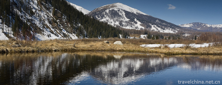
The Altai mountains are located in the northern part of the Xinjiang Uygur Autonomous Region and the western part of Mongolia. Northwest extends to Russia. The Altai Mountains in China are situated on the south slope of the middle section of the Altai Mountains, with an altitude of 1000-3000 meters. The main ridge is above 3000 meters, and the highest peak in the north is friendship peak, 4374 meters above sea level.
The forest line is about 1800-1900 meters high, covering an area of 161,1457 hectares, of which 100,000 hectares belong to super-protected areas, rich in forest and mineral resources. Average annual temperature is 0 degrees Celsius, with an average temperature of 15-17 degrees Celsius below the snowline in July and a minimum temperature of minus 62 degrees Celsius in winter, with an average annual precipitation of 500-700 mm.
"Altai" means "Jinshan" in Mongolian. It began to mine gold in the Han Dynasty, and more than 50,000 people were in the mountains in the Qing Dynasty. The Altai language is named after al Taishan.
The Altai Mountains of the Central Asian Mountains span part of China, Mongolia, Russia and Kazakhstan, stretching about 2,000 km from the Gobi (desert) to West Siberia, with a northwest-southeast trend.
There are modern glaciers; the western mountains are the widest, narrower and lower toward the southeast; from the northeastern China border, the mountain power gradually decreased from the northwest to the southeast to about 3000-3500 meters. There is a Northwest fault in the piedmont of the mountain, and it gradually descends to the Ertix River Valley in the south-west direction, showing four steps, and the outline of the mountain is massive and stratified; there is only glacial erosion topography and modern glaciers in the high mountain area, which is the modern glacier distribution center in the northernmost part of China; there is no large-scale fault basin except that the faulted basin is Beaded along the NW faults. Longitudinal valley; Al Taishan is a typical fault block mountain. The Tianshan Mountains, Kunlun Mountains, Tarim Basin and Junggar Basin formed "three mountains and two basins".
Ranging mountains separate the waters of large rivers such as the Obi and its main tributary, the Ertix, from those flowing into the vast Central Asian basins. Rivers that originate in mountainous areas are controlled by faults and flow northwest into the Ertix River, becoming the upper Obi River and the only river flowing into the Arctic Ocean in China. The vertical distribution of mountain vegetation is obvious. Below 1100 meters is the foothill grassland belt; between 1100 and 2300 meters is the forest belt, growing Siberian pine, Siberian fir, spruce and so on; above 2300 meters is the mountain meadow belt and the subalpine meadow belt, is a good summer pasture. There is a small amount of agriculture in low mountain basins. Mountain areas are rich in nonferrous metals (including gold deposits).
geology
The geological structure belongs to the Altai geosyncline fold belt. The mountain body first appeared in Caledonian movement, and formed the basic outline in the late Variscian period. After that, the mountain body was basically reduced to a quasi-plain. The Himalayan movement caused the mountain body to move and rise along the NW-trending faults, thus forming the present Altai Mountains. A magnitude 8 earthquake occurred in 1931. Along with a nearly north-south fault, it lasted 40~60 kilometers.
The hills in the northern part of the Altai Mountains divide them from the West Siberian Plain, and the north-eastern part of the Altai Mountains connects with the West Sayan Mountains. The Altai Mountains of Mongolia rise to become the Peak of Friendship (Nayram Dalin Peak, 4374 meters), then extend southeast and then east. The Gobi Altai Mountains, which began about 483 kilometers southwest of the Mongolian capital Ulan Bator, occupy the southern part of the country and stand in the Gobi Sea.
The Altai Mountains are round in shape, with a wide range of moraines on the slopes, U-shaped valleys with U-shaped valleys, and ancient ice buckets arranged in layers. Sheep's back rocks, side tills, middle tills and terminal tills can be clearly seen. Altai Mountain has a multi-level planation surface, generally recognized as a four-level, 2010 statistics, altitude are 2900-3000 meters, 2600-2700 meters, 1800-2000 meters and 1400-1600 meters. Geomorphological vertical zoning is obvious, from high to low: modern ice and snow action zone, altitude over 3200 meters, with Friendship Peak and Kuitun Peak as the center, the development of valley glaciers, glaciers, suspended glaciers. In addition, there are also modern glaciers in the upper source of the Aqur and Aqur Rivers around Lake Aqur; the frost zone, 2400-3200 m (2010 statistics), with clear paleo-glacial erosion topography, snow cover for 8 months, mainly cold weathering; the erosion zone, 1500-2400 m, mainly cutting by running water; and the dry denudation zone Below 1500 meters. Kanas comprehensive natural landscape protection area is located at the edge of this belt.
Soil from high to low, mainly distributed in glacial marsh soil, alpine meadow soil, subalpine meadow soil, grass ashed soil, gray forest soil, calcareous black soil, chestnut soil, calcareous brown soil and so on.
The regional climate is completely continental, and the winter is long and cold due to the influence of the Asian anticyclone, i.e. the high-pressure region. In January, the temperature ranged from - 14 C in the hills to - 32 C in the shaded valleys of the eastern part of the country. In the Chu River steppe, the temperature dropped sharply to - 60 C. Occasionally there are one or two permafrost zones, which belong to permafrost covering vast areas of northern Siberia. July's temperatures are warm and even hot --- usually 24 degrees Celsius during the day, sometimes as high as 40 degrees Celsius on low slopes --- but summer is brief and cool in most parts of the highlands. In the west, especially in the Highlands between 1524 and 1981 meters, the precipitation is high, about 20 to 40 inches, and the annual precipitation can reach 80 inches. Continue to the East, the total precipitation can be reduced to 1/3, and in some areas there is no snow at all. The peak flank of glacier covers 1500 or so, covering an area of about 648 square kilometers.
Mount Altai is located in the arid desert and arid semi-desert areas of the hinterland of Asia. Westerly circulation brings water vapor to the Atlantic Ocean. Rainfall is more abundant, precipitation increases with altitude and decreases from west to east, more in winter and summer, less in spring and autumn, annual precipitation of 200-300 mm in low mountains, and more than 600 mm in high mountains; snowfall is more than precipitation, and the time of snow accumulation is prolonged with the increase of altitude. Snow cover in middle and high mountains is as long as 6-8 months, in low mountains only 5-6 months, and snow line is as low as 2800 above sea level. Rice is the lowest snow line in China, and the temperature change decreases with height. The vertical gradient of climate in Altai mountain area is obvious, with the characteristics of long winter, short summer and no spring and autumn.
The whole region has a continental climate with warm and rainy summers, cold winters, little snow in valleys and heavy snow in alpine areas. The average annual temperature here is 0 degrees, of which the average temperature below the alpine snow line in July is 15-17 degrees, and the lowest temperature in winter is - 62 degrees. The average annual precipitation is between 500-700 millimeters.
The Taishan river is rich in runoff and has developed the rivers of the Er Qi Qi and the Wu Lun Gu river. Both rivers constitute a typical asymmetric comb water system. The Erqis River is the only outflow River in Xinjiang. According to statistics in 2010, the basin in China covers an area of 50,000 square kilometers, with a total length of 546 kilometers. Flow into the Arctic Ocean. The tributary of the Wulungu River lies in the mountainous area, with a total length of 573 km in front of the mountain. Finally, the tributary is located in the Wulungu Lake (Brento Sea and Fuhai Sea). Over the two stations, the area of the basin is 22,000 square kilometers. The main source of recharge is winter snow, with an average annual runoff of 1.1 billion cubic meters. The upper reaches of the two rivers have many Gorges and faulted basins with large drop, clear water flow, less sediment and about 500,000 kilowatts of hydraulic reserves.
Landforms
Mount Altai is rich in cultural heritage, and a long time ago a large number of Paleolithic relics were unearthed. Here is a record of the ups and downs of many tribal peoples on this land. Genghis Khan, Skita, Turkey, Uighur and Mongolia all left their historical footprints here, and it was not until the mid-18th century that Altai officially belonged to the Czar Russia. Jinshan al Taishan's most notable historical site is the tombs of tribal leaders in the fifth Century. These tombs are complex in structure and of different sizes. The total number of these tombs can reach more than 100. Many of the works of art buried are even more rare.
Al Taishan has al Taishan aborigines, Russians and Kazakh settlers. Native Altai tribes (such as the Altai-Kichi) account for a considerable proportion of the Altai population. Horse breeding is very common in this area. In the north, cattle and cattle are the main source, while the dry south is suitable for sheep, goats and camels. The cattle herder in the south must migrate extensively to make up for the shortage of water grass. The nomads set up temporary dwellings called yurts at their destination, a circular structure of felt and latticed hides. The traditional mode of grazing is inferior to a more stable way of settling down. Their main occupation is livestock, including cattle, sheep and horses. Russians and Kazakans are mainly engaged in agriculture and animal husbandry or mining. Large mines and non-ferrous metals (copper, lead and zinc) smelters are concentrated in the Altay Mountains in Rudny, Kazakhstan and Altay. Their energy needs are supplied by the Ust-Kamenogorsk and Bukhtarma hydropower stations. Altai has well-developed forestry and wood products industry and light industry including food processing.
Kanas Scenic Area
Kanas Scenic Spot is located in the Altai Mountains, the region since ancient times for many northern nomadic areas. The discovery of the fine stone relics on the North Bank of Erqis River shows that there were people engaged in hunting, fishing and hunting activities as early as 8,000 to 9,000 years ago. Historically, there have been many grassland tribes, such as Cypriots, HuJie, Huns, Xianbei, Rouran, Turks, Tiele, Mongolia, Kazakhstan and so on.
The Friendship Peak, which stretches across the Altai Mountains in northern Xinjiang, is covered with ice and snow all the year round. It is one of the lowest modern glaciers in China. The Kanas Lake lies on the southern slope of the scenic Friendship Peak, covering an area of about 250,000 square hectares in the Kanas National Reserve.
Boolen
Burgen Province was founded in 1937. It is composed of several adjacent counties at the junction of Serenger, Hangai, Kusugur and Central Provinces. The province is located in the Hangai Mountains and forest grasslands of northern Mongolia. It borders Russia on the South with the former Hangai Province, on the East with the central and Serenge provinces, on the West with the post-Hangai and Kusugur provinces, and on the north. The province is distributed in the Hangai Mountains, Hantai Buzhig, Abu Dhag, Wurentaogao, Hohhot Nohan, Bragan and other mountains. The northern part belongs to hang AI district. There are a lot of Aloux and lakes in Burgen Province with heavy snowfall in winter. The rivers such as Hate, Sereng, Tarbagtai, Orhun and Tula in the main provinces, and the lakes such as Hargall Lake, Sharga, Cecalamari Mountain Root, Oren, Alhan Lake and Hunte Lake can cure diseases.
Cara mare Hill
Mount la Mare is located in the six Division of Nong. The ungulate nature reserve is located in the eastern part of China. There are wild horses, wild donkeys, pan sheep, goose throat Ling and other desert rare animals in this area. There are abundant historic sites, including the imperial palace of the Tang Dynasty, the ancient city of Beiting, the Xida Temple, Qitai Qianfo Cave, the ancient road of Dongshi, many ancient peaks burning, ancient tombs and primitive village sites, all of which have high historical research and ornamental value.
Fuhai
Fuhai Lake is a kind of Ulungur Lake called Ulungur Lake, also known as the Brento Sea, Dahaizi (adjacent Jili Lake is called Xiaohaizi), located in Altay, Xinjiang, China, Fuhai County. The elevation of the lake is 468 meters. The lake is triangular in shape, about 30 km in width from north to south, 35 km in length from east to west, 827 square kilometers in area and 8 meters in depth on average.


-
Dunhua Liudingshan Cultural Tourist Area
Dunhua Liudingshan Cultural Tourist Area is located in the South Bank of Mudanjiang River, 3 kilometers south suburb of Dunhua City.
Views: 147 Time 2018-12-05 -
Longting Hotel East China Sea Shenzhen
Langting's history can be traced back to 1865. The grand opening of Langting Hotel in central London, England, has become the first truly "luxury hotel" in European history, creating a brill.
Views: 582 Time 2018-12-16 -
Fairy Lake Xianhu Botanical Garden
Xianhu Botanical Garden is located in Liantang Xianhu Road, east suburb of Luohu District, Shenzhen. It relies on Wutong Mountain in the East and Shenzhen Reservoir in the west..
Views: 119 Time 2018-12-22 -
Liu Jiawan Chaihai Garden
Located on the eastern coast of Taolu Town, Donggang District, Rizhao City, Liujiawan Chaihai Garden is a national AAAA-level tourist attraction, a popular science education base, and a core scenic sp.
Views: 113 Time 2018-12-26 -
Jizu Mountain Scenic Spot in Binchuan
Jizu Mountain is located in a cave-making area about 20 kilometers west of Binchuan County, Yunnan Province, 90 kilometers away from Dali City. It is named for its three peaks in the front and a ridge.
Views: 140 Time 2019-01-03 -
Tianhetan Scenic Area
Tianhetan is located in Shibanzhen, Huaxi District, Guiyang City, Guizhou Province. It is a scenic spot with typical karst natural scenery as the main part and historical celebrities.
Views: 117 Time 2019-02-21 -
Jiangnan Shaoxing opera
Yueju Opera, the second largest opera in China, is also known as "the most widely circulated local opera" . Some people think that it is "the largest local opera",.
Views: 147 Time 2019-05-05 -
Puning Ying Song
Puning Yingge is a traditional folk dance style widely spread in Puning City, Guangdong Province. It was created and compiled by Yitang people during the reign of Qianlong in the Qing Dynasty. It has .
Views: 119 Time 2019-06-09 -
Zhou Cuns Baking Cake Making Skills
Zhou Cun's baking technology has a history of more than 1,800 years. According to Zizhi Tongjian, in the three years since Emperor Heng of Han Dynasty Yanxi, Hucai vendors have been exiled in Shandong.
Views: 290 Time 2019-08-10 -
Aba Teachers University
Aba Teachers College, formerly Aba Teachers College, is a full-time general college approved by the State Council in December 1978. In 1993, it was renamed Aba Teachers College. The school was origina.
Views: 227 Time 2019-08-31 -
Cai Yuanpei
Cai Yuanpei (January 11, 1868 - March 5, 1940), word crane Qing, also the word Zhong Shen Cai Zhen, Zhou Ziyu, Han nationality, Shanyin County, Shaoxing Prefecture, Zhejiang (now Zhejiang). Shaoxing (.
Views: 180 Time 2019-09-06 -
Climate of Yibin
Yibin City has a humid monsoon climate in the middle subtropics, and the low hills and river valleys have the climate attributes of south subtropics. It has the characteristics of mild climate, abundant heat, abundant rainfall, suitable illumination, long fr.
Views: 354 Time 2020-12-18
